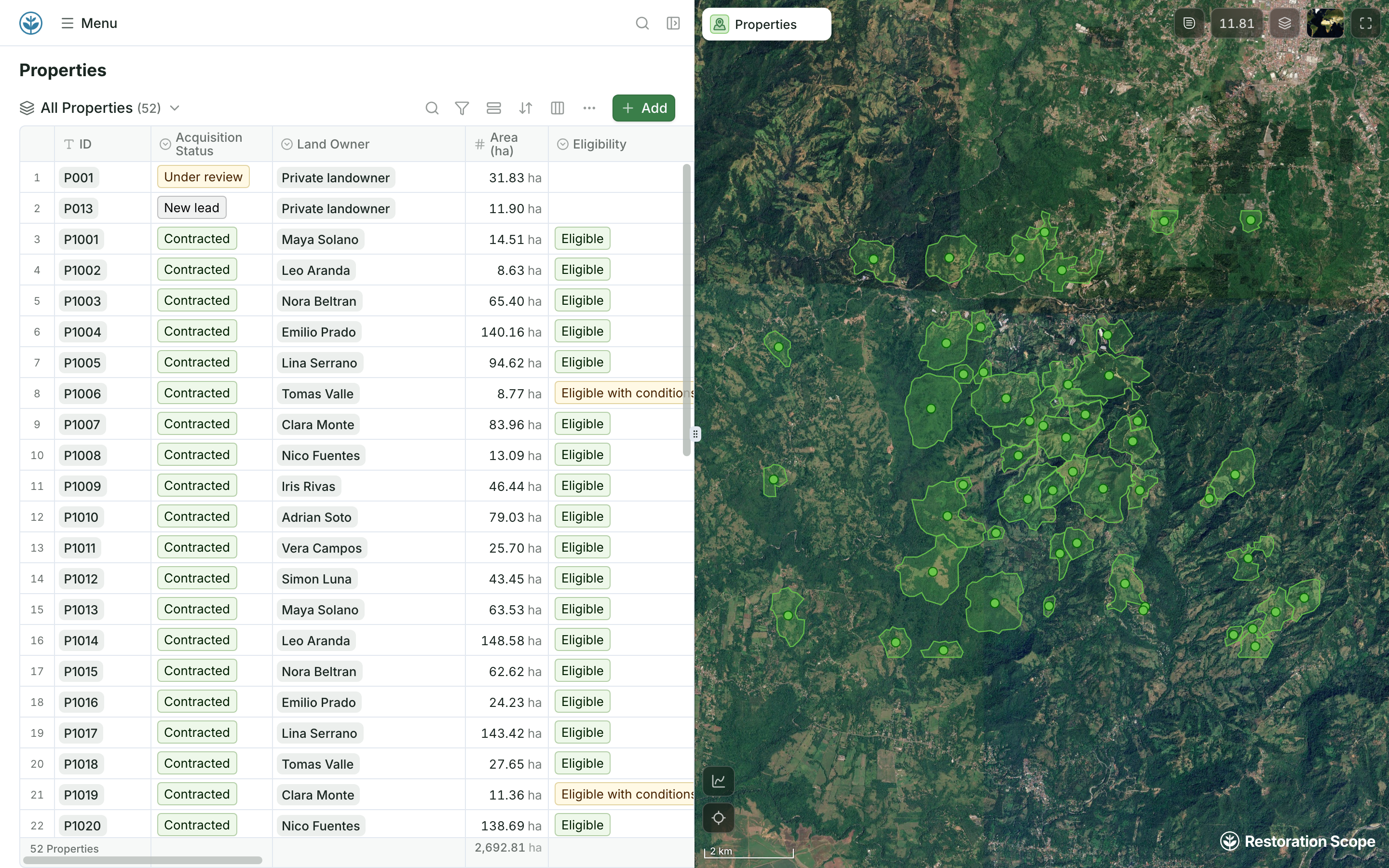
A live project map for the whole team
Records and their boundaries side by side in the browser, the same ones field teams see in Restoration Scope Field.
Restoration Scope is where field teams, coordinators and funders run the project from the same sites and records; it is not a desktop GIS. QGIS is free, open-source desktop GIS for analysis and mapping.
 Restoration Scope
They do different jobs, so many teams use both. For running the project, Restoration Scope is the best fit for most teams: field teams, coordinators and funders work from the same sites and records, including people who never open a GIS. QGIS is free desktop GIS for an analyst doing analysis, cartography or custom processing. Analysis stays in QGIS, and its exported layers reach the rest of the team in Restoration Scope.
Restoration Scope publishes this comparison and is one of the options. We list it first because we think it's the best fit for most projects: it adapts to each project and grows with it, and covers operations and costs as well as fundraising and reporting. No vendor paid to be included. Something out of date? Write to info@restorationscope.com.
| Restoration Scope |  QGIS | |
|---|---|---|
| What it is | The system that runs a nature project: sites, field work, surveys, maps, results and funder reporting. The field app and its surveys are part of it. | Free, open-source desktop GIS (GNU GPL) for Windows, Mac and Linux. |
| Cost | A free pilot on a sample of your data, then a platform license plus implementation, quoted after a scoping call. | Free, “forever”, in the project’s own words. |
| Who uses it | Field teams, coordinators and funders, each with their own view. | GIS users. Analysis and cartography reward training. |
| Analysis | Geospatial data layers, and project-specific analysis workflows built with our team. | A deep analysis toolset with chained processing workflows and plugins. |
| Maps | A live project map of sites and records, in the browser and Restoration Scope Field. | Cartography and a print layout designer for publication-quality maps. |
| Field capture | Restoration Scope Field works offline: points, lines, polygons and photos. | Desktop software. Field teams pair it with companion apps such as QField. |
| Records over time | Sites, visits and seasons linked as records. | Layers and attribute tables you structure and maintain. |
| Donor reporting | Donor portals built from the same records the team keeps. | Exported maps and reports, or layers published to the web. |
QGISAnalysis stays in QGIS.QGISIts results are exported as layers: Shapefile, GeoJSON, KML, GeoTIFF.Restoration ScopeField teams, coordinators and funders see them with the project records.Layers exported from QGIS (Shapefile, GeoJSON, KML, GeoTIFF) come into Restoration Scope, so analysis stays in QGIS and its results reach the rest of the team.
Checked against QGIS's own pages on October 17, 2026: QGIS, QGIS features.
These are Restoration Scope screens from our demo project and a public donor portal. To see QGIS, visit its own site.
Records and their boundaries side by side in the browser, the same ones field teams see in Restoration Scope Field.
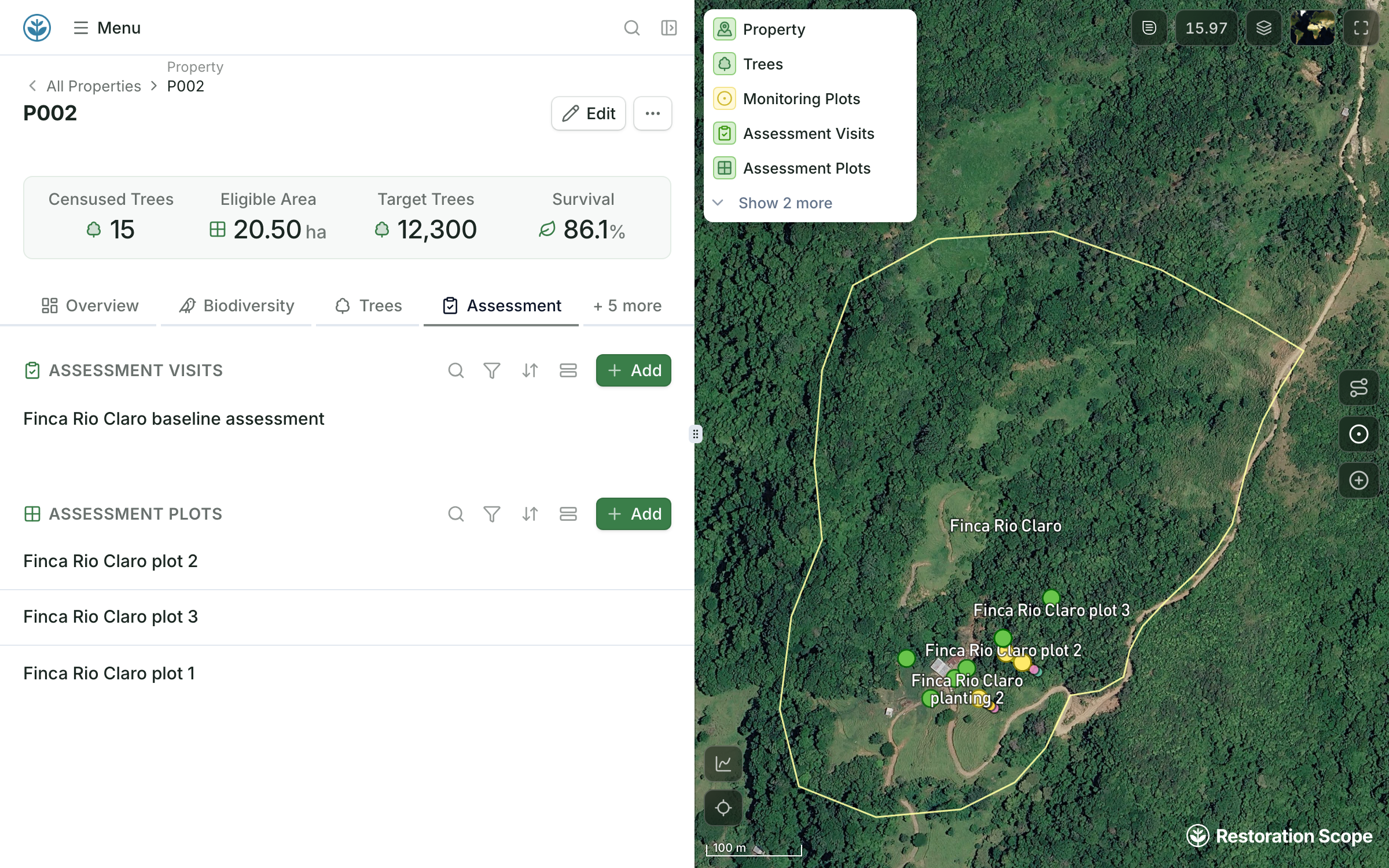
Each site links its monitoring plots and visits, so its history stays in one place.
QGIS is desktop GIS that works as one part of a network of tools, beside spreadsheets and a field app. Restoration Scope is an adaptable platform that keeps records and maps together and brings your GIS files in as layers.
Where restoration records live, from word of mouth to custom softwareYes. QGIS is free and open source under the GNU GPL, for Windows, Mac and Linux.
For running the project, yes: Restoration Scope is where the whole team works from the same sites and records, and it takes in layers made in QGIS. For GIS analysis and cartography, keep QGIS.
Yes. Shapefile, GeoJSON, KML and KMZ, and GeoTIFF files come in and attach to your sites.
No. Field teams use Restoration Scope Field and coordinators use the web app. GIS skills help when you bring in or analyse layers.
Another question? Email us or book a call.
Bring in the spreadsheets, field forms and maps you already use, and see every site in one place.