Land and landowners in the same system
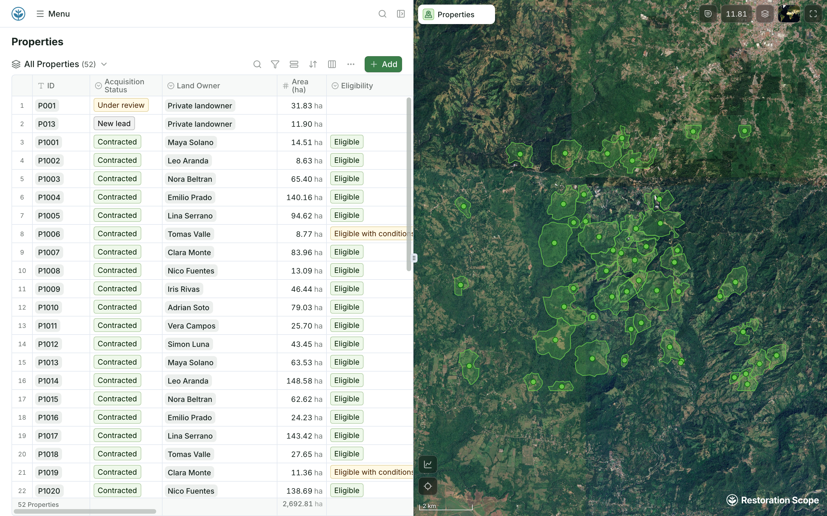
Properties carry their acquisition status, landowner, area and eligibility, next to their boundaries on the map.
Restoration Scope keeps a project’s land, field and monitoring records, configured around the project, under whichever standard it uses. Open Forest Protocol (OFP) is a carbon registry that comes with its own monitoring tech: an offline forester app, monitoring every six months and then yearly, verification by its validator network, and credits for reforestation and agroforestry projects from 0.3 ha, at no up-front cost. Its team also built NatureGrid, a monitoring platform.
 Restoration Scope
It depends on what you need. For one system set up with you around the whole project, from land agreements and partners to field work and donor portals, under whichever standard you use, Restoration Scope is the best fit for most projects. If you want to register and issue credits on one registry that brings its own monitoring tools, even for a small project, and OFP’s credits suit your buyers, OFP is built for that. NatureGrid, from the same team, is monitoring software with a free trial.
Restoration Scope publishes this comparison and is one of the options. We list it first because we think it's the best fit for most projects: it adapts to each project and grows with it, and covers operations and costs as well as fundraising and reporting. No vendor paid to be included. Something out of date? Write to info@restorationscope.com.
| Restoration Scope | ||
|---|---|---|
| What it is | A restoration data platform configured around your project: land and landowner records, a field app, monitoring, maps and portals. | A carbon registry for forest projects, which its site calls a digital carbon standard, with its own monitoring tech: an operator dashboard, an offline forester app and a public Atlas of project data. Its team also built NatureGrid, a monitoring platform. |
| Cost | A free pilot on a sample of your data, then a platform license plus implementation, quoted after a scoping call. | As of October 2026: no up-front cost for project developers. A 2023 OFP article puts its protocol fee at 8% of the credits issued; ask OFP for current terms. NatureGrid has a 14-day free trial; its prices aren't published. |
| Credits | We don’t issue or sell credits. We keep the records behind them, under whichever standard you use. | Ex-post credits, issued yearly after verification, for afforestation, reforestation, revegetation and agroforestry projects from 0.3 ha. |
| Monitoring | Plots, trees and site visits on your methodology’s schedule, linked to each site across seasons. | Every six months for the first two years, then yearly. Organisations in its validator network check the ground data. |
| Field app | Restoration Scope Field works offline: field teams record surveys, photos and planting areas on the same property maps the office sees. | The forester app works offline on any smartphone. NatureGrid adds custom forms, monitoring zones, sample plots and remote sensing layers. |
| Who sees the data | Records stay with your team. Donor portals, per donor or programme, show what you set up for them. | Project data is shown on its public Atlas, which it describes as an immutable public record. |
| Land and partners | Land and landowner records, partner programmes and data from Kobo, Google Sheets and GIS files in the same system. | Land tenure and site survey data are part of a project’s eligibility review before it registers. |
Checked against Open Forest Protocol's own pages on October 19, 2026: For project developers, NatureGrid, NatureGrid announcement, Protocol fee (2023), Project eligibility.
These are Restoration Scope screens from our demo project and a public donor portal. To see Open Forest Protocol, visit its own site.
Properties carry their acquisition status, landowner, area and eligibility, next to their boundaries on the map.
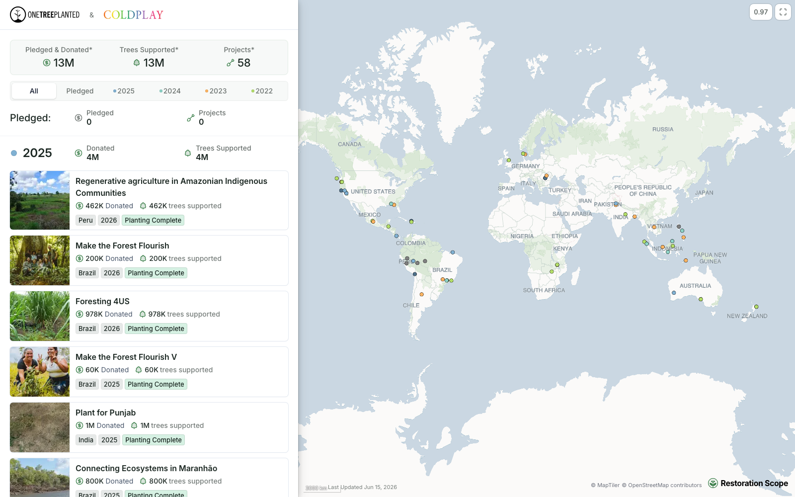
Each donor or programme gets their own portal, built from the same records the team keeps.
Open Forest Protocol sits beside the ladder: it is a registry that comes with its own monitoring tech. Restoration Scope is an adaptable platform that keeps a project’s records under whichever registry or standard it uses.
Where restoration records live, from word of mouth to custom softwareA monitoring platform built by the Open Forest Protocol team and announced in June 2026: an offline mobile app for observations, photos and plot data, and a web dashboard with validation workflows and remote sensing layers. It works across project types and monitoring frameworks, and offers a 14-day free trial.
Its site says projects join at no up-front cost, whatever their location and size. A May 2023 OFP article puts its protocol fee at 8% of the credits issued; ask OFP to confirm current fees and terms.
Yes. Restoration Scope is not tied to a standard: it keeps land, plot and monitoring records set up for your methodology. We are not a registry or a verifier, and we don’t issue credits.
For the project’s records, yes; for registering and issuing credits, no. OFP is a registry with its own monitoring tech. Restoration Scope keeps the project’s records under the standard you choose.
Another question? Email us or book a call.
Bring in the spreadsheets, field forms and maps you already use, and see every site in one place.