
Plots and trees on each site
A site keeps its boundary, monitoring plots and plantings, with censused trees and survival rate beside them.
Restoration Scope runs what happens on the ground: land, field teams, plots and their measurements across seasons. Kanop is an MRV data provider: satellite and AI estimates of carbon stocks for due diligence, project design and monitoring, at 10 or 30 m with confidence intervals. It was among the first three providers Verra vetted for VM0047 stocking-index data, in May 2026. Many reforestation carbon projects need both.
 Restoration Scope
Usually both, for different jobs. To run the project on the ground, with land agreements, field teams and plots measured every season, Restoration Scope is configured around that, and Kanop’s site does not describe field operations. For biomass estimates, a dynamic baseline or eligibility maps, Kanop provides them and Restoration Scope does not. Kanop can recalibrate its estimates with your plot measurements, so the two fit together.
Restoration Scope publishes this comparison and is one of the options. We list it first because we think it's the best fit for most projects: it adapts to each project and grows with it, and covers operations and costs as well as fundraising and reporting. No vendor paid to be included. Something out of date? Write to info@restorationscope.com.
| Restoration Scope |  Kanop | |
|---|---|---|
| What it is | A restoration data platform configured around your project: land and landowner records, a field app, monitoring, maps and portals. | An MRV data provider: satellite and AI estimates of carbon and land use, through a web app, an API and expert services. |
| Cost | A free pilot on a sample of your data, then a platform license plus implementation, quoted after a scoping call. | Not published. Demos on request. |
| Carbon estimates | We don’t estimate biomass or carbon from satellite data. Pair us with a provider such as Kanop. | Its core: biomass and carbon stock layers at 10 or 30 m with 95% confidence intervals, from optical and radar satellite data, trained on lidar. |
| Baselines and VM0047 | We don’t build baselines or write PDDs. We keep the plot and monitoring records your methodology asks for. | Among the first three providers Verra vetted for the VM0047 performance benchmark, in May 2026; Verra added four more in September. It says it has delivered more than 30 VM0047 dynamic baselines, and it drafts PDD sections. |
| Field data | Field teams record surveys, photos and planting areas offline in Restoration Scope Field; plots and trees keep their observations across seasons. | An optional input: your plot measurements can recalibrate its estimates, and it supplies sampling protocols. Its site does not describe a field app. |
| Land | Parcels, landowners and eligible area, moving through a pipeline from first conversation to contract. | Eligibility maps at 30 m show which land qualifies and why. Its site does not describe landowner records or land agreements. |
| Outputs | Sites, plots and boundaries on a satellite map. GIS files, including GeoJSON and GeoTIFF, come in as layers. | CSV, GeoJSON and raster files through its web app and API, and reports for auditors and buyers. |
Restoration ScopeField teams measure plots; each tree joins its plot and site.KanopKanop recalibrates its satellite estimates with those plot measurements.Restoration ScopeIts GeoJSON and raster files come in as layers beside the plots.Keep Kanop for the estimates and Restoration Scope for the ground. Field teams measure plots in Restoration Scope, Kanop recalibrates its estimates with those measurements, and its GeoJSON and raster files come back in as layers beside the plots.
Checked against Kanop's own pages on October 19, 2026: Kanop, For project developers, VM0047 support, Verra vetted providers.
These are Restoration Scope screens from our demo project and a public donor portal. To see Kanop, visit its own site.
A site keeps its boundary, monitoring plots and plantings, with censused trees and survival rate beside them.
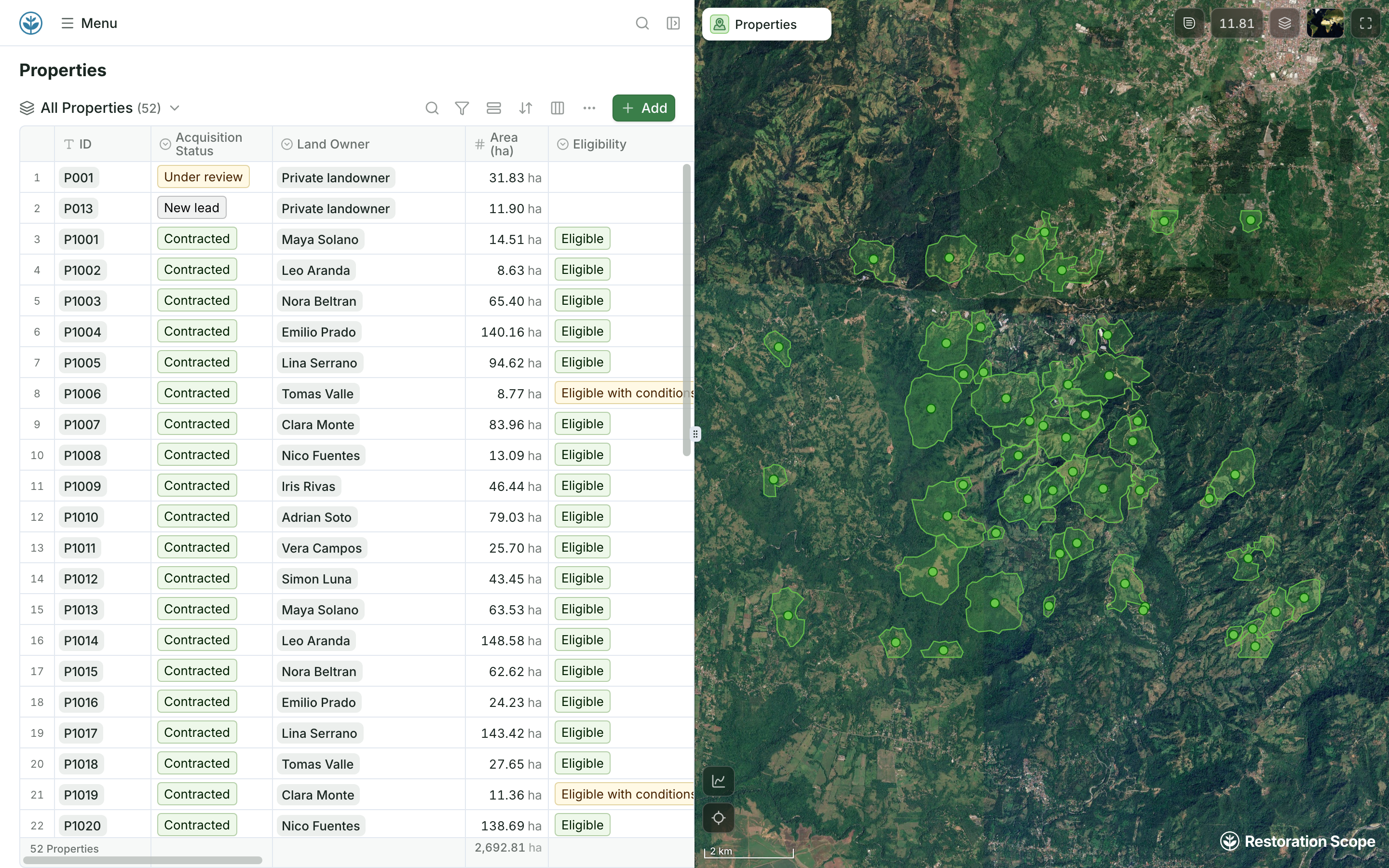
Properties carry their acquisition status, landowner, area and eligibility, next to their boundaries on the map.
Kanop is not where project records live; it is a data source whose satellite estimates feed whichever level your records sit on. Restoration Scope is an adaptable platform that keeps the plots and land those estimates rest on.
Where restoration records live, from word of mouth to custom softwareIts site describes field data as an optional input: plot measurements recalibrate its estimates, and it supplies sampling protocols. It does not describe a field app. Restoration Scope Field records surveys, photos and planting areas offline.
Yes. In May 2026 Verra named Sylvera, Kanop and Chloris Geospatial as vetted providers of stocking-index data for the VM0047 performance benchmark, and added Treefera, CYCLOPS, Lobelia Earth and TransparenC in September 2026. Using one is optional.
Yes, through files. Plot measurements from your field records can recalibrate Kanop’s estimates, and Kanop’s GeoJSON and raster outputs come into Restoration Scope as map layers beside the plots.
Kanop does not publish prices; it offers demos on request. Restoration Scope offers a free pilot on a sample of your data, then quotes a platform license plus implementation after a scoping call.
Another question? Email us or book a call.
Bring in the spreadsheets, field forms and maps you already use, and see every site in one place.