Best ARR Carbon Monitoring Software in 2026: The Buyer's Shortlist
The best ARR carbon monitoring software in 2026: Restoration Scope for most projects, Kanop for satellite data, ODK and QField for plots, BlueLayer for credits.
What is the best ARR carbon monitoring software in 2026?
The best ARR carbon monitoring software for most projects in 2026 is Restoration Scope, which publishes this guide: it keeps land, field, plot and monitoring records in one place, set up around your methodology. Most developers add a satellite data provider: Kanop, Chloris Geospatial and Sylvera were the first three Verra vetted for VM0047, in May 2026. For a plot app on its own, ODK or KoboToolbox, or QField if your plots are designed in GIS. For credits across a portfolio, BlueLayer.
Disclosure: Restoration Scope publishes this guide and is one of the options below. We list it first because we think it's the best fit for most projects: it adapts to each project and grows with it, and covers operations and costs as well as fundraising and reporting. No vendor paid to be listed, and there are no affiliate links.
As of October 2026: facts about each tool come from its own website or documentation, linked in each entry, and were checked on October 19, 2026. Prices change; confirm them with the provider.
Key takeaways
- Join the records first, then buy the satellite data. Most ARR projects need land, field and plot records in one place, which is what Restoration Scope is for, plus a satellite data provider for biomass and baselines. Choose the provider for the job it does best.
- Free field apps can record plot inventories. ODK, KoboToolbox, QField and Open Foris Arena record trees per plot offline. The hard part is keeping plot IDs stable across years and tied to the land and monitoring records around them.
- Verra has vetted seven satellite data providers for VM0047. Sylvera, Kanop and Chloris Geospatial in May 2026, then Treefera, CYCLOPS, Lobelia Earth and TransparenC in September. They supply the stocking index behind the performance benchmark, and using them is optional.
- Field apps publish prices; most others quote. Sylvera has a free tier, Chloris a free viewer and Open Forest Protocol no upfront cost, but Restoration Scope, paid satellite data and credit platforms are quoted per project. Ask for a quote scoped to your hectares and crediting period.
- Test a revisit before you buy. Measure a plot, go back with another person and another phone, and check that the plot, its trees and the change still line up. That's what a verifier will trace.
What ARR carbon monitoring software is (and what it isn't)
An afforestation, reforestation and revegetation (ARR) carbon project earns credits for carbon that new trees take up. Monitoring software records the evidence behind those credits: which land is in the project, what was planted, what the sample plots measured, what the satellite data says, and how each number traces back to its records.
It covers six jobs:
- Land and eligibility: parcels, landowners, land cover history and the plantable area, before anything is planted.
- Plot inventory in the field: trees per plot with species, diameter and height, recorded offline.
- A plot database across years: plot IDs, locations and measurements you can trace at every verification. Under Verra's
VM0047, monitoring data must be archived electronically until two years after the last crediting period.
- Remote sensing: biomass estimates, a dynamic baseline or control plots, depending on the method.
- Boundaries in the registry's format: valid polygons that change as the project grows.
- Evidence for the verifier: records, photos and calculations someone outside the team can trace.
It isn't a registry, a verifier or a methodology. Verra, Gold Standard or another standard sets the rules and issues credits; an accredited body verifies them. Software can't make a project eligible or additional. It also isn't the carbon calculation itself: the methodology's equations decide the credits, and the software feeds them clean data. Read what your standard asks first; our guide to carbon standards for nature projects compares them, and ARR carbon standards goes deeper on reforestation.
How we ranked these tools
We scored each tool on five criteria you can check on its own website:
- ARR jobs covered: how many of the six jobs above the tool's own site says it does for forest or ARR projects. Reports and analysis a verifier can trace count as evidence.
- Offline field capture: whether field teams can record plots without a connection.
- Named for ARR methods: whether it names VM0047 or is one of Verra's vetted VM0047 data providers.
- Published price: whether its price is on its website, and the entry price.
- Data you keep: whether it's open source, or states an export or API for your data.
We didn't score ease of use, support or accuracy, because we can't measure them fairly across tools. This is an editorial shortlist by job. Restoration Scope, our own product, comes first because we think it's the best fit for most ARR projects; the other tools follow the order a project meets each job, field apps first, then satellite data, then credit and registry platforms.
The best ARR carbon monitoring software in 2026
Twelve tools: Restoration Scope first, as our pick for most projects, then the rest grouped by the job each is built for.
1. Restoration Scope, best for most ARR projects
Restoration Scope, which publishes this guide, is a field data and monitoring platform for ARR carbon developers. Parcels, landowners and eligibility move through a pipeline from first conversation to contract; field teams record planting, plots and trees offline on the same maps; and plots, trees and maintenance keep their repeated observations, so each number traces to its records.
Why Restoration Scope is our pick for most ARR projects: Restoration Scope adapts to your methodology, plot design and team instead of making you fit its workflow, and it grows with the project, from a first planting season to many sites and verifications. It holds the whole project in one place, so the same records help run field operations and keep costs in view, and give investors, credit buyers and verifiers a transparent trail. No other tool on this list does all of that.
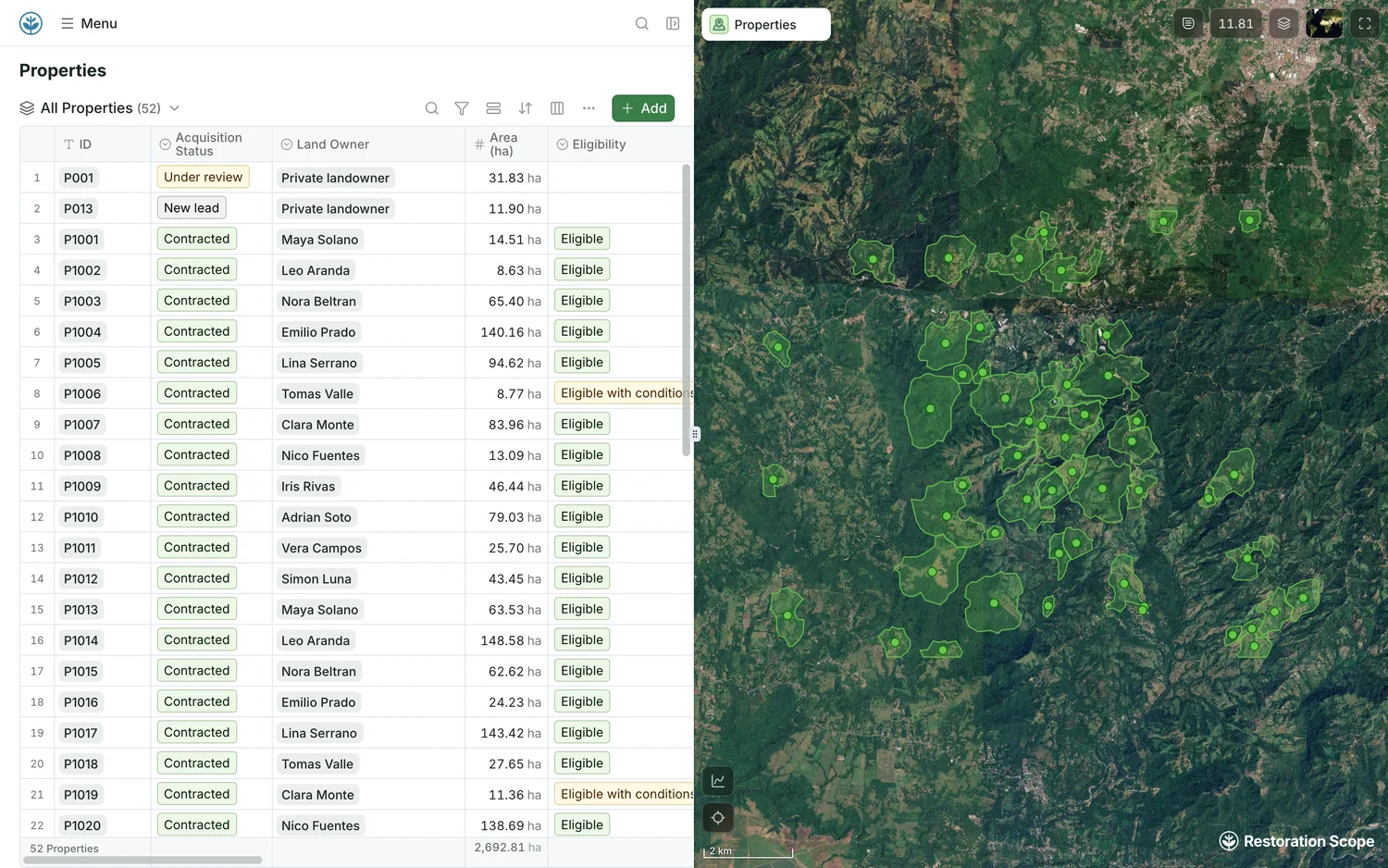
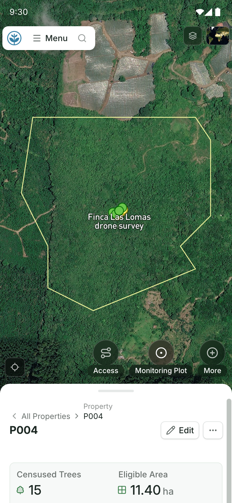
Land and eligibility in one view.
Each property's acquisition status, landowner, area and eligibility, beside its boundary on the map. Field teams open the same kind of property on their phones: its boundary on the map and its record below. Demo project: names and numbers are made up.
Restoration Scope is not a satellite data provider, a registry or a verifier, and it does not calculate credits. Its pricing is a free pilot on a sample of your data, then a platform license plus implementation, quoted after a scoping call. Tables export as CSV and boundaries as GeoJSON or KML.
Restoration Scope is best suited for: most ARR developers, and especially those whose land, field and monitoring data sits in separate spreadsheets, forms and GIS files. Pair it with a satellite provider for biomass and baselines. For one small project with a single plot form, a free field app and a spreadsheet may be enough.
2. ODK, best for free plot inventories you revisit every year
ODK is an open-source field app for forms, offline, with GPS and photos. Its Entities feature helps when you revisit the same plots and trees each year; it comes with ODK Cloud Professional ($499 a month billed annually) or self-hosting. ODK Cloud starts at $199 a month billed annually. ODK supports offline maps and forms linked to mapped features.
Best suited for: a team that can design its own forms and keep plot IDs stable between visits. Pick a GIS app instead if you draw and edit plots and strata in the field. See ODK vs Restoration Scope.
3. KoboToolbox, best for nonprofits that want free hosted forms
KoboToolbox is a form builder and offline collection app, open source. Dynamic data attachments let a form pull in earlier records, which helps on repeat plot visits. It's free for nonprofits; companies pay from $25 a month.
Best suited for: nonprofit-led ARR projects with simple plot forms. Developers registered as companies should compare its paid plans with ODK Cloud. See KoboToolbox vs Restoration Scope.
4. QField, best for plots and strata designed in GIS
QField takes QGIS projects into the field. Its forest inventory setup covers fixed and variable-radius plots, nested plots, and per-tree species, diameter, height and photos, with external RTK GPS. QFieldCloud has a free tier, and paid plans start at €18 per user a month billed annually (€14 from 20 users).
Mergin Maps is a similar QGIS-based option, from €15.8 per contributor a month billed annually; ArcGIS Field Maps suits teams already on ArcGIS, priced by Esri user type.
Best suited for: teams with a GIS owner who designs plots and strata. Without one, forms, layers and sync have no maintainer. See QField vs Restoration Scope.
5. Open Foris Arena, best for inventory specialists
Open Foris Arena, from FAO, designs, collects and analyses forest inventory data, with an offline mobile app. It comes from national forest inventories and is free and open source.
Best suited for: a team with inventory expertise that wants the analysis next to the data. You design the survey and the analysis yourself.
6. Terraware, best for developers running their own nurseries
Terraware, from Terraformation, is free and open source. It covers seed banks, nurseries, planting plans and offline monitoring plots, and calculates survival and biomass. Terraformation uses it to monitor its own VM0047 projects.
Best suited for: developers who grow their own seedlings and want monitoring plots built in. If your plot design follows your methodology rather than Terraware's, check the fit first. See Terraware vs Restoration Scope.
7. Kanop, best for VM0047 baselines calibrated with your plots
Kanop supports due diligence, project design and monitoring, with 10–30 m layers and confidence intervals, optional recalibration with your field data, an API, and an MCP server that connects its data to AI assistants such as Claude and ChatGPT. It says it has delivered more than 30 VM0047 dynamic baselines, and it was one of the first three providers Verra vetted. It also covers REDD+, IFM and blue carbon. Price not published.
Best suited for: developers who need a dynamic baseline and want their plot data to tighten the estimate. See Kanop vs Restoration Scope.
8. Chloris Geospatial, best for biomass history back to 2000
Chloris Geospatial offers annual 30 m biomass stock and change data since 2000, and dynamic baselines for VM0047, delivered as files a verifier can review. It also supports site screening and due diligence. It was one of the first three providers Verra vetted. A free viewer screens sites at 30 m; other prices aren't published.
Best suited for: projects that need a long, consistent record of biomass change for eligibility, baselines or control areas.
9. Sylvera, best when buyers also want ratings
Sylvera is best known for carbon credit ratings and market data. It also sells 30 m biomass data, annual since 2000, and was one of the first three providers Verra vetted. It has a free tier; paid plans aren't priced on its site.
Best suited for: developers whose credit buyers already use Sylvera ratings, or who want data and an independent rating from one company.
10. Treeconomy, best for blending drone and field data
Treeconomy models biomass per hectare at 10 m with uncertainty, combining satellite data with your field and drone data. It offers VM0047 eligibility assessments, and its case studies include VM0047 assisted natural regeneration. Its Project Launchpad gives a free initial biomass model; other prices aren't published. It isn't on Verra's list of vetted VM0047 providers.
Best suited for: projects that already fly drones or measure many plots and want them in the biomass model.
11. BlueLayer, best for managing credits across a portfolio
BlueLayer is software for carbon project developers: project management, the credit lifecycle from estimate to retirement, sales, a digital MRV module with an offline mobile app, and integrations with registries through an API. Its customer stories include a VM0047 reforestation portfolio. Price not published.
Best suited for: developers with several projects and a credit pipeline to manage. If your pain is forest field operations, note that BlueLayer's field app stories are about biochar, not forest plot inventories. See BlueLayer vs Restoration Scope.
12. Open Forest Protocol, best for small projects that want registry and monitoring in one
Open Forest Protocol is a carbon registry for forest restoration that comes with its own monitoring tech: an offline field app, field data checked by validators with satellite imagery, and credit issuance under its own ARR methodology. It checks eligibility, accepts ARR and agroforestry projects from 0.3 hectares at no upfront cost, and asks for field inventories every six months for the first two years, then yearly; project data becomes a public record. It doesn't publish a price list. In June 2026 the same team launched
NatureGrid, monitoring software for developers who issue credits elsewhere.
Best suited for: projects, including small ones, that want one registry with its own monitoring tools. If your buyers expect Verra or Gold Standard credits, it's a different path. See Open Forest Protocol vs Restoration Scope.
Side-by-side comparison
Scored on the five criteria above, from each tool's own website as of October 2026.
| Tool | Best for | ARR jobs (of 6) | Offline field capture | Named for VM0047 | Published price | Data you keep |
|---|---|---|---|---|---|---|
 Restoration Scope | Most projects: land, field and plot records in one place | 4: land, plots, plot records, evidence | Yes | No | No | Yes, CSV and geospatial exports |
 ODK | Plots you revisit | 2: plots, plot records | Yes | No | Yes, Cloud from $199/month billed annually | Yes, open source |
 KoboToolbox | Nonprofit forms | 2: plots, plot records | Yes | No | Yes, free for nonprofits; companies from $25/month | Yes, open source |
 QField | GIS-designed plots | 3: plots, plot records, boundaries | Yes | No | Yes, free tier; paid from €18/user/month billed annually | Yes, open source |
| Open Foris Arena | Inventory specialists | 3: plots, plot records, evidence | Yes | No | Yes, free | Yes, open source |
 Terraware | Own nurseries | 3: plots, plot records, evidence | Yes | Partly, used on Terraformation's VM0047 projects | Yes, free | Yes, open source |
 Kanop | Calibrated baselines | 3: land screening, remote sensing, evidence | No | Yes, vetted | No | Yes, API, exports and MCP |
| Chloris Geospatial | Biomass since 2000 | 2: land screening, remote sensing | No | Yes, vetted | Partly, free viewer | Yes, API and CSV |
| Sylvera | Data with ratings | 1: remote sensing | No | Yes, vetted | Partly, free tier | Yes, API |
| Treeconomy | Drone and field blends | 2: land screening, remote sensing | No | Yes, eligibility and case studies | Partly, free initial model | Not documented |
| Credit portfolios | 2: field records, evidence for the verifier | Yes | Yes, in case studies | No | Yes, API and registry integrations | |
| Registry with monitoring | 5: land, plots, plot records, remote sensing, evidence | Yes | No, its own methodology | Partly, no upfront cost | Partly, data becomes a public record |
"Not documented" means the sources we reviewed don't say.
Which ARR tool fits your project
| Your situation | Start with | Add | Watch out for |
|---|---|---|---|
| Most ARR projects: land, landowners, field work and plots to keep together | Restoration Scope | A satellite provider | No published price; scoped per project |
| First ARR project, small team, tight budget | ODK or KoboToolbox | A vetted satellite provider when the baseline is due | Plot IDs drifting between visits |
| Plots and strata designed by a GIS analyst | QField | Kanop or Chloris for biomass | Nobody maintaining the GIS project |
| You grow your own seedlings | Terraware | A satellite provider; a plot app if your design differs | Plot design that doesn't match your methodology |
VM0047 dynamic baseline due | Kanop, Chloris or Sylvera | Your field plots, to calibrate | Uncertainty deductions on credits |
| Several projects, credits to sell | BlueLayer | Field apps for plots | Field operations it doesn't cover |
| Small project, no registry yet | Open Forest Protocol | — | Buyers who expect Verra or Gold Standard |
Where does Restoration Scope fit in an ARR developer's stack?
Replaces: Spreadsheets of parcels, plots and trees, form exports joined by hand, and boundaries kept as loose KML files and shapefiles.
Works beside: KoboToolbox or ODK forms a team keeps, with an import or sync we set up; a satellite provider such as Kanop, Chloris or Sylvera for the VM0047 baseline, whose files come in as map layers beside the plots; and the registry, which receives the boundary file and issues the credits.
Stays the developer's: The methodology and monitoring plan, the credit calculation, and the validation/verification body (VVB) the developer contracts.
Some tools above overlap with Restoration Scope: Terraware also runs nurseries and monitoring plots, and BlueLayer and Open Forest Protocol have their own field apps. Our explainer What is dMRV? shows where each kind of tool sits in the chain.
What results look like
Restoration Scope's carbon work so far is with developers, at the land and field end of their projects:
Ponterra develops smallholder reforestation carbon projects in Panama and Mexico. We built a tool to track landowner engagement and data sharing for investors.
Living Carbon reforests abandoned mine land in the US. We built land prospecting with their science and GIS team, combining suitable properties, plantable land and mine permits.
- Acción Andina, a restoration programme rather than a carbon project, shows the records side: 16 partner organizations across 6 Andean countries, with 120 seasons of data from 23 projects joined into one database and map.
See all our partners, or read the Acción Andina case study.
How do you choose software for an ARR carbon project?
- Start from your methodology. Its monitoring plan decides the plot design, the measurements, the remote sensing and how often you measure. Pick tools that fit it, not the other way round. VM0047 field data covers what Verra's method asks of your plots.
- Decide what stays in-house. Field data and plot records are yours to keep for decades. Satellite estimates and credit management can be bought as services. Know which data you'd lose if a vendor left.
- Ask providers about uncertainty. Your standard deducts or limits credits when error is too high. Ask each satellite provider how it reports uncertainty and whether your plots can reduce it.
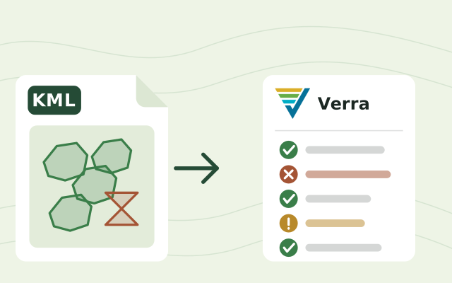
- Keep boundaries valid as you grow. New planting areas and dropped parcels all change the registry file. Check it with the free Verra geolocation file checker before each verification.
- Plan the verifier's view. Ask someone who has been through verification to trace one number from a report back to its plot records. Whatever they can't follow is what your stack is missing.
For the whole developer stack across project types, see the best software for carbon project developers. For field apps in depth, see field-data apps, and for monitoring beyond carbon, restoration monitoring tools compared. Before a field test, the free GPS accuracy test shows how precise each phone is on site.
Talk through your ARR stack with us
If your land, field and plot records live in different places, a short call is the quickest way to see whether we fit. We'll look at what you track today, which parts your methodology needs, and which tools above you already have. If a field app and a spreadsheet are enough for your project, we'll say so. If not, we'll show you how a setup like Ponterra's or Living Carbon's would look with your data. Book a call.
Frequently asked questions
What software do ARR carbon project developers use?
Most need two things. A place where land, field and plot records live together, such as Restoration Scope, or a mix of a field app (KoboToolbox, ODK, QField or Open Foris Arena), spreadsheets and GIS files; and a satellite data provider such as Kanop or Chloris for biomass or baseline data. The records hold the plots, measurements and documents a verifier will review.
Which satellite data providers has Verra vetted for VM0047?
Verra named Sylvera, Kanop and Chloris Geospatial as the first vetted providers of stocking-index data for VM0047's performance benchmark in May 2026, and added Treefera, CYCLOPS, Lobelia Earth and TransparenC in September 2026. Using them is optional, and vetting doesn't guarantee Verra accepts a project's data.
Is there one platform that does ARR monitoring from field to credit?
Not on its own. Restoration Scope, our pick for most ARR projects, keeps land, field capture, plots and monitoring records in one place, set up around your methodology, but it does not issue or sell credits. Open Forest Protocol combines monitoring with issuance on its own registry, and BlueLayer manages credits across a portfolio. No tool replaces the registry or the verifier.
How often does an ARR carbon project have to be monitored?
It depends on the standard. Under Verra's VM0047, most parameters are monitored at least every five years, and Gold Standard asks for verification at least every five years. Many developers measure plots more often to catch problems early.
Can a free field app handle carbon plot inventories?
Yes, for collection. ODK, KoboToolbox, QField and Open Foris Arena can all record trees per plot with species, diameter and height, offline. The work is in keeping plot IDs stable across years, checking the data, and producing what the verifier asks for. ODK Entities can follow the same trees and plots across visits if your team designs that data model; in Restoration Scope we set those links up with you, beside the land and monitoring records.
How much does ARR monitoring software cost?
Field apps publish prices, from free (Open Foris Arena, Terraware, KoboToolbox for nonprofits) to $199 a month for ODK Cloud, or $499 for ODK Cloud Professional, billed annually. Some data providers have a free entry point (a Sylvera free tier, a Chloris viewer, a Treeconomy initial biomass model) and Open Forest Protocol has no upfront cost. Restoration Scope, BlueLayer and paid satellite data are quoted; ask each for a quote scoped to your hectares and years.
Do I need a satellite data provider or a field census system for VM0047?
Usually both, for different jobs. Under VM0047's area-based approach you measure sample plots in the field and buy a dynamic performance benchmark from remote sensing, often from a Verra-vetted provider. Its census-based approach, for dispersed planting such as agroforestry and shelterbelts that doesn't change land use, counts every planted tree and has no remote-sensing benchmark, so the field records, tree by tree with GPS or markers, carry the evidence.
What happened to Pachama?
Carbon Direct announced in November 2025 that it had acquired Pachama, to bring Pachama's forest monitoring technology into its own services. Carbon Direct now trades as Relae.
Another question? Email us or book a call.