ARR Carbon Credits and Projects: 9 Standards Compared
How afforestation, reforestation and revegetation (ARR) projects earn carbon credits under Verra VM0047, Gold Standard, Plan Vivo and six more: eligible land, monitoring, forward credits and ICVCM status.
ARR carbon projects, short for afforestation, reforestation and revegetation, earn credits for the carbon that new trees take up. Every major standard certifies them, and the differences show up in the details: what land qualifies, how removals are measured, whether you can sell credits before the trees grow, and how long you keep monitoring.
This guide compares ARR methodologies across nine standards. It compares published rules, not outcomes, and is not legal or investment advice. First-party documents checked October 18, 2026. For the wider field, see carbon standards for nature projects compared.
How ARR carbon credits are made
An ARR carbon credit stands for one tonne of CO₂ equivalent that new trees or other vegetation take out of the air, net of the project's own emissions and counted above what the land would have stored without the project. Under the UN climate convention's definitions, ARR covers three activities:
- Afforestation: establishing forest, by planting, seeding or assisted natural regeneration, on land that hasn't been forested for at least 50 years.
- Reforestation: bringing forest back the same ways to land that was forested and then cleared.
- Revegetation: establishing vegetation on at least 0.05 hectares that counts as neither. Carbon methodologies such as Verra's VM0047 credit woody plants: shrubs, trees on farms or bamboo.
The path from land to credits is much the same under every standard:
- Land eligibility. Show that the land meets your methodology's land-history rules, usually no forest for about 10 years, though some accept degraded land or forest not managed for wood, and that you hold the rights to the land and its carbon.
- Standard and methodology. Pick the program and the methodology version. They set every rule below, and whether your credits can carry the ICVCM label.
- Baseline. Estimate what the land would have grown without you, from satellite control areas, unplanted plots, regional data or a fixed rule, depending on the methodology.
- Planting. Plant, or assist natural regeneration, and record species, dates and areas by stratum.
- Monitoring. Measure carbon the way your methodology says, with sample plots, satellite data or a census of planted trees, and track survival, replanting and disturbance.
- Validation and verification. An independent auditor, a validation and verification body (VVB), checks the project design at validation and the measured removals at each verification.
- Issuance. The registry issues credits for verified removals, after the buffer share and any leakage or uncertainty deductions. Forward credits, below, are the main exception.
When the first credits come. Under most standards, at the first verification, once a verifier has checked the removals; buyers can still pre-finance before it. Three routes issue credits earlier, and two standards set a deadline for the first verification:
 Gold Standard A/RForward credits for up to five years of expected removals on planted area the verifier has confirmed, except to smallholder projects that use default values for baseline, leakage and carbon uptake. New projects are being moved to the STARR draft.
 Plan Vivo PM001Forward credits for up to 90% of the removals expected over the crediting period, before the buffer. Not under PM002.
 Climate Action ReserveForecasted units for US reforestation, through Climate Forward.
CercarbonoThe first verification is due within five years of the project start.
 ACRThe first verification can wait up to 12 years while trees establish.
 Verra,
 Isometric,
BioCarbon and
Equitable EarthCredits only for verified removals.
Definitions from the UNFCCC's Kyoto Protocol decision 16/CMP.1 and
VM0047; Gold Standard's forward-credit rule from its
GHG product requirements; standards' rules from the sources under each table below.
Compare reforestation methodologies
| Standard | Methodology | Eligible land | Removals measured by | Forward credits | ICVCM label |
|---|---|---|---|---|---|
| Verra VCS | VM0047 v1.1 | Non-forest land; area-based also takes forest not managed for wood products in the past 10 years | Biomass plots against satellite control plots, or a census of every planted tree | No | Approved |
| Gold Standard | A/R v2.1 | Not forest in the past 10 years, with reviewed exceptions; no wetlands | Growth models checked by inventory plots | Yes, up to 5 years ahead | Under assessment |
| Plan Vivo | PM001; PM002 for smallholder agroforestry | No deforestation or clearing in the past 10 years, with set exceptions | Field data or local models; PM002 uses satellite models calibrated by plots | Partly, PM001 only, up to 90% | Not listed |
| ACR | A/R of Degraded Lands v1.2 | Land shown to be degraded or degrading | Stratified plots at ±10% precision | No | Approved |
| Climate Action Reserve | US Forest Protocol; Climate Forward for forecasts | US land with little canopy for 10 years, or after a disturbance | Inventory plots grown forward with approved models | Partly, Climate Forward only | Not listed for ARR (Mexico reforestation under assessment) |
| Isometric | Reforestation v1.2; Agroforestry v1.1 | Degraded or historically forested land, no deforestation in 10 years | Field plots, against a satellite control-pixel baseline | No | Approved (Reforestation 1.1, Agroforestry 1.0) |
BCR0001 v5.0 | Not forest or natural vegetation in the past 5 years; no wetlands | Stratified plots at ±10% precision | No | Under assessment | |
CM-LU-002 v3.1 | No stable forest in the past 10 years; at least 10% of the area managed for biodiversity, or verified equivalent actions where the land can't reach that | Field inventory, with remote sensing checked in the field | No | Under assessment | |
M001 v1.3 | Degraded land returning to forest or woodland, checked over 10 years; afforestation excluded | Equitable Earth's satellite biomass maps, pixel by pixel; optional LiDAR plots to calibrate them | No | Approved |
Verra's census-based approach takes up to 50 planting units per hectare on land that stays in use.
Status from the ICVCM assessment page, checked November 6, 2026. ICVCM approves versions, not names, so check the version you would use.
Latest versions and what changed
Standards revise their rules on different schedules, and which rules apply to your project depends on its methodology version and the program's transition rules. Below: the latest version of each ARR methodology, read from the standard's own pages, with what its last revision changed, in our words.
| Standard and document | Latest version | Published | Before that | What the last revision changed | What's next | Official source |
|---|---|---|---|---|---|---|
| Verra VCS Standard | v5.0 | December 16, 2025; most new rules apply to requests from July 1, 2027 | v4.7 (April 2024), still usable until July 1, 2027 | New rules on right to operate, stakeholder engagement and environmental and social safeguards, with new templates | No next version dated | |
Verra VM0047 | v1.1 | May 14, 2025 | v1.0 (September 2023); v1.0 projects had to be listed by December 31, 2025 and must request registration by December 31, 2026 | Clearer rules on which forested land area-based projects may use, updated census rules, revised handling of existing woody biomass and soil disturbance, remote sensing allowed for biomass already on site | No next version dated | |
| Gold Standard A/R methodology | v2.1 | May 16, 2024 | v2.0 (October 2022) | Spells out how to show additionality and how to count removals that would have happened without the project | STARR is the planned replacement; its draft consultation closed May 22, 2026, and no final version was found by November 7, 2026 | |
| Plan Vivo PV Climate requirements | V5.7 | April 30, 2026 | V5.6 (March 2026); five versions since July 2025 | The rule against registering a project twice became a formal requirement, and benefit sharing must follow national law | No next version dated | |
Plan Vivo PM001 and PM002 | v1.0 each | PM001 November 2023; PM002 listed September 29, 2025 (its PDF is dated October 29) | None, both first versions | PM002 added a satellite-model method for smallholder agroforestry | No next version dated | |
| ACR A/R of Degraded Lands | v1.2 | May 2017; corrections May 2022 | v1.1 | Wetlands became eligible, with limits on hydrology, species and soil disturbance; projects may leave soil carbon out | v2.0 in development, no dates | |
| Climate Action Reserve US Forest Protocol | v5.1 | July 20, 2023 | v5.0 (October 2019) | Reforestation is a project type again, Climate Forward projects can move over, planting on native grassland is barred, and different project types can be combined if the Reserve approves and nothing is counted twice | No next version dated | |
| Climate Forward Reforestation | v2.0 | April 29, 2022; corrections October 2024 | v1.1 (May 2020) | Forecast units can, under conditions, move into the Reserve's offset program; sites can be grouped; consent rules for communal land; a risk discount and pool replace the abandonment discount | v2.1 in progress, no dates | |
| Isometric Reforestation | v1.2 | April 30, 2026; latest patch September 25, 2026 | v1.1 (October 2025) | Moved to Isometric's Protocol Requirements 2.0 | No next version dated. ICVCM lists v1.1 as approved; v1.2 is not listed | |
| Isometric Agroforestry | v1.1 | April 30, 2026; latest patch September 23, 2026 | v1.0 (February 2026) | Updated its carbon accounting and eligibility modules under a new accounting framework | No next version dated. ICVCM lists v1.0 as approved; v1.1 is not listed | |
BCR0001 | v5.0 | November 5, 2025 | v4.0 (February 2024) | BioCarbon's own tool is now required for additionality and baseline; restoration activities are explicitly in scope; new rules for reversal risk, leakage and uncertainty; a stronger monitoring plan with an option for digital monitoring | No next version dated | |
LU-002 | v3.1 | December 30, 2025 | v2.2 (March 2025); v3.0 (July 2025) was the consultation draft | Finalized v3.0 after consultation and independent review. v3.0 made revegetation its own activity, apart from woody crops | No next version dated | |
v1.3 | October 2, 2026 | v1.2 (August 2025) | Changed who qualifies and how additionality is shown, set out leakage and control-plot monitoring more fully, counts emissions from fuel burned, revised uncertainty rules. ICVCM approved v1.3 on October 19, 2026, announced November 3 | No next version dated |
Each standard's own methodology page or document history, checked November 7, 2026. Changes are summarized in our words; the linked page has the full text.
What each standard asks you to monitor
| Standard | Verification at least | Crediting period | Commitment | Buffer |
|---|---|---|---|---|
Verra VM0047 | Most parameters every 5 years | 20–100 years | At least 40 years | Pooled, sized by Verra's risk tool, at least 12% |
| Gold Standard | Every 5 years, with an inventory before each | 30–50 years | The crediting period | 20% |
| Plan Vivo | Every 5 years, with annual reports | 10–50 years | Risk assessed over at least 50 years | 20% |
| ACR | Every 5 years with a site visit; the first can wait up to 12 years | 40 years | At least 40 years | Pooled, sized by ACR's risk tool |
| Climate Action Reserve, US | Annual reports; a site visit at least every 6 reporting periods, or 12 for small projects, with conditions | Set by the protocol | 100 years after each issuance | Pooled, by risk rating |
| Isometric | Reporting periods of 1–5 years | Set by the protocol | Reforestation: 40–100 years of monitoring after crediting. Agroforestry: 40–120 years in total | 20%, or set by a risk model, at least 10% |
| Every 5 years | 40 years, or 20 renewed once | 20 years of reversal monitoring for projects starting by 2026, then 40 | 10–30% by risk, plus 10% | |
| Every 3 years; the first within 5 | 20 years, renewable | At least 40 years | Buffer tool plus insurance or equivalent | |
| Every 1–5 years, with annual reports | 40 years, renewable in 20-year blocks up to 100 | Satellite loss monitoring for 100 years after the project ends | 20% |
 Plan Vivo requirements v5.7
Where each standard fits
Verra VCS
Good fit: Most ARR projects, in any country, selling to the largest buyer market. VM0047 has two approaches: area-based, which compares project plots with matched satellite control plots, and census-based, which counts every tree planted on farms and other land that stays in use. See what VM0047 asks you to record.
Plan for: No credits issued before the first verification, though buyers can still pre-finance. Today an ARR project completes validation within 8 years of its start date. For registration requests from July 1, 2027, under VCS version 5, the request is due within 8 years of the crediting start instead, unless the project was already listed as under validation by December 16, 2025. From the same date, a geolocation file of the project and any control areas the methodology uses is due at validation and each verification. If you plan to sell to airlines: in a REDD+ country, a VM0047 project expected to issue more than 7,000 credits a year can't get Verra's CORSIA label unless it is nested in a jurisdictional program under Scenario 2a (Verra's CORSIA rules; every standard compared).
Gold Standard
Good fit: Projects that need early income. Forward credits for up to five years of removals on planted area the verifier has confirmed can fund planting; 20% of them go to the buffer. Agroforestry and silvopasture qualify, and smallholders can map their land with a GPS point and a hand-drawn or digital map.
Plan for: Change. Projects had until June 30, 2026 to apply for preliminary review under Gold Standard's older methodologies; later ones must use a Paris-aligned methodology, and credits from 2026 on can only be issued under one. For ARR that is STARR, still a draft, so check with Gold Standard before you start, including whether forward credits carry over.
Gold Standard STARR methodology
STARR, Gold Standard's Sustainable Transformation through Afforestation, Reforestation and Revegetation methodology, will replace its A/R methodology. It is still a draft: public consultation closed on May 22, 2026, and the draft says the final version takes effect 90 days after Gold Standard publishes it. Gold Standard invites new projects to ask for a preliminary review under the draft, but the final version must be applied before validation.
The draft sorts projects into five modules, from commercial forestry to revegetation, and three tracks, set by module and scale:
- Track 1: a dynamic baseline from satellite pixels matched to the project area. Commercial forestry and large-scale production agroforestry must use it.
- Track 2: regional growth curves approved by Gold Standard or a national authority where they exist; otherwise national forest inventory data from at least 30 plots in the same administrative district or zone, updated within five years.
- Track 3: a capped static baseline, open only to smallholder projects.
For smallholders, the draft lets each farm's perimeter serve as the project boundary when every tree is recorded in a census with a GPS point. On Track 2, the draft checks leakage in agroforestry by whether the main subsistence crop's yield falls by no more than 10%, and lets subsistence agroforestry and smallholder groups cut the buffer from 20% to 10% where the trees provide fruit, fodder or other benefits worth more than 20% of farm income. Its crediting periods run 40 to 100 years, up from 30 to 50, and existing projects with a 30-year period will move to at least 40.
Sources: 
consultation page,
Gold Standard's STARR FAQ, Paris Agreement alignment schedule. Checked November 6, 2026; the draft may change before publication.
Plan Vivo
Good fit: Community and smallholder planting. PM002, for smallholder agroforestry plots of 0.1 to 10 hectares, estimates biomass with satellite models calibrated by at least 30 plots per ecoregion at the start and every five years. At least 60% of credit-sale income, after host-country charges, must benefit participants and local stakeholders over the crediting period.
Plan for: No ICVCM label for its methodologies yet. Compare it with the alternatives in Plan Vivo vs Gold Standard vs Verra.
ACR
Good fit: Reforestation of land you can show is degraded, with the ICVCM label.
Plan for: A 40-year crediting period and term. The first verification can wait up to 12 years while trees establish. ACR also asks you to keep unplanted regeneration areas in each stratum and check them every 10 years, to test whether the land would have regrown on its own.
Climate Action Reserve
Good fit: US reforestation after long-term loss of cover or a disturbance such as wildfire. Its sister program Climate Forward issues forecasted units up front from default growth curves, after a one-time check that at least 70% of plots are stocked.
Plan for: 100 years of monitoring after each issuance under the US Forest Protocol, and annual monitoring reports.
Isometric
Good fit: Buyers who want a satellite control baseline and a public registry with the project data. Its agroforestry protocol covers land where at least half the area, or 500 hectares, produces non-timber products.
Plan for: Field plots throughout crediting, measured at the start and end of each reporting period, or at least every five years when LiDAR or biomass maps estimate growth, and monitoring for 40 to 100 years after crediting ends under the reforestation protocol.
 BioCarbon Standard
Good fit: Latin American projects that want explicit field rules. BCR0001 lists the records it expects: an ID for every lot, GPS points for plots and lots, planted polygons by stratum, species and date, survival three months after planting and later, and a log of every disturbance.
Plan for: A buffer of 10% to 30% by risk, plus a general 10%.
 Cercarbono
Good fit: Projects in Colombia and Chile, where Cercarbono credits are recognized in compliance schemes, and projects that want to show biodiversity management: at least 10% of the area must be managed for it, or the project takes equivalent conservation actions.
Plan for: More frequent verification than most, at least every three years.
 Equitable Earth
Good fit: Restoring degraded land, or helping degraded forest regrow through assisted natural regeneration, without running your own carbon inventory: Equitable Earth calculates credits from satellite biomass maps, pixel by pixel.
Plan for: No forward credits. Afforestation isn't eligible. M001 version 1.3 has carried the ICVCM label since October 2026 (ICVCM's decision). Field plots only calibrate the maps, must be LiDAR scans, and the calibration protocol has been paused since July 2026.
Sources: M001 v1.3, field calibration protocol, Equitable Earth Standard v1.3.1, Programme Manual v1.3.1.
How buyers and raters judge an ARR project
The standard decides whether you get credits. Buyers look further: the ICVCM label, the buffer, what you planted, who benefits, and often an independent rating built from your project documents and satellite data. Plan for each when you design the project.
- ICVCM label. A credit carries the Core Carbon Principles (CCP) label only when it is issued under a CCP-approved methodology and a CCP-eligible program. All nine standards here are CCP-eligible programs; which ARR methodology versions are approved is in the comparison table.
- Buffer and commitment. Every standard here guards against fire, pests and other reversals, usually with a buffer of set-aside credits, and all but Climate Forward's forecast route bind you to decades of monitoring: see what each standard asks you to monitor. Raters look past the buffer to the risks themselves: fire, drought, pests, land tenure and whether landholders keep the trees.
- Native species and biodiversity. MSCI scores planting from 1, a monoculture of non-native trees, to 5, a diverse mix of native species, and caps commercial non-native plantings at 2. Sylvera says single-species plantations are more exposed to drought, pests and disease. Some standards set a floor: Cercarbono asks for at least 10% of the area managed for biodiversity, or verified equivalent conservation actions where the land can't reach that share, and Equitable Earth's M001 requires native species.
- Community benefit. Where smallholders or communities hold the land, raters check who receives what, when, and whether it is enough to keep them planting. Plan Vivo requires at least 60% of credit-sale income, after host-country charges, to benefit participants and local stakeholders over the crediting period.
What ratings agencies check in your project. BeZero, Sylvera and MSCI publish how they rate ARR, and Calyx Global publishes its general approach; all four test additionality (would the trees have been planted without carbon finance?), over-crediting and permanence. Beyond that:
BeZero looks at common practice nearby, your project's finances and benefit-sharing, including whether payments depend on tree survival or credit issuance.
Sylvera checks reported growth against satellite canopy height, and its 2022 ARR framework treats land the developer deliberately cleared of native ecosystems in the 10 years before the start as ineligible when it is more than 5% of the project.
MSCI scores survival rates against outside data and how often you monitor, in an ARR methodology updated in October 2026, rating regular monitoring with field plots and remote sensing, with public monitoring reports, highest.
Calyx Global rates additionality, over-crediting, permanence and overlapping claims, rates each SDG claim separately, and says its higher-rated reforestation, forest management and blue carbon projects choose conservative baselines even where the methodology doesn't require them.
Keep these ready: boundary files of every planted area, species lists, survival records, plot data and evidence that carbon finance made the project happen. Sylvera says a missing shapefile is the most common gap that stops it from fully assessing a project.
Sources: ICVCM assessment status and its M001 decision,

Sylvera ARR framework (2022) and Sylvera's approach to ARR ratings,
MSCI ARR methodology,
Calyx Global's approach and its chief scientist on nature ratings. Checked November 6, 2026.
What your field team has to keep
Whichever standard you choose, the field record looks much the same:
- Land history. Imagery or other evidence that the land had no forest for the lookback period, and legal title or rights.
- Boundaries and strata. GIS polygons for the project area and each stratum or planting unit, and, once VCS version 5 applies, a geolocation file at validation and each verification.
- Planting. What was planted, where and when, by species and cohort, against the planting plan.
- Plots or trees. A location you can find again for every sample plot, or for every tree under VM0047's census approach, with the measurements the methodology asks for.
- Survival and disturbance. Mortality checks, replanting, fire, pests and grazing, with dates and locations. See how to track tree planting survival.
- Procedures. Field SOPs, QA checks and the original data, kept for the life of the project.
Restoration Scope keeps planting, plots, trees, survival checks and photos connected on one map, with offline capture for field teams. It doesn't calculate credits or replace your methodology expert. See Restoration Scope for carbon projects.
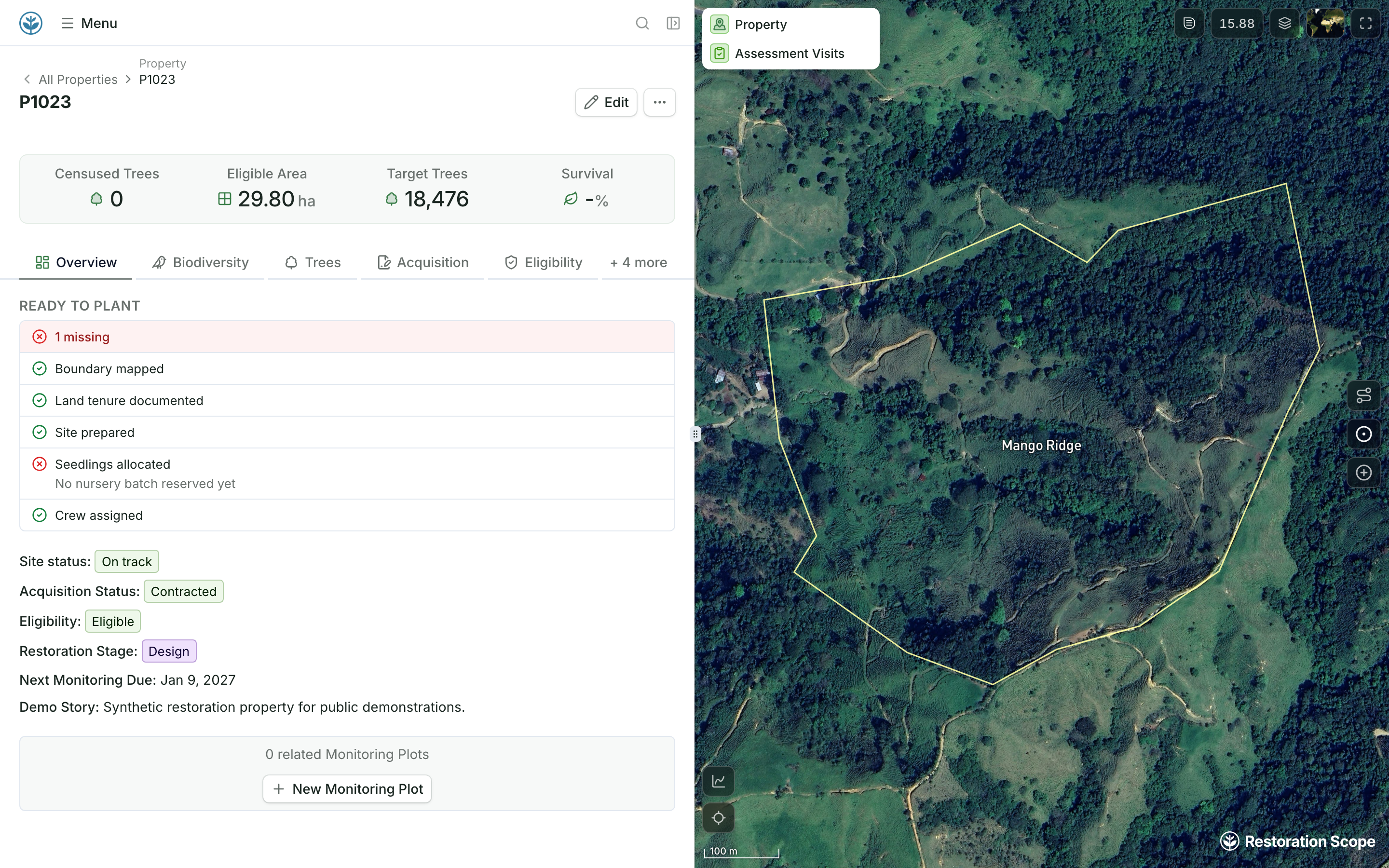
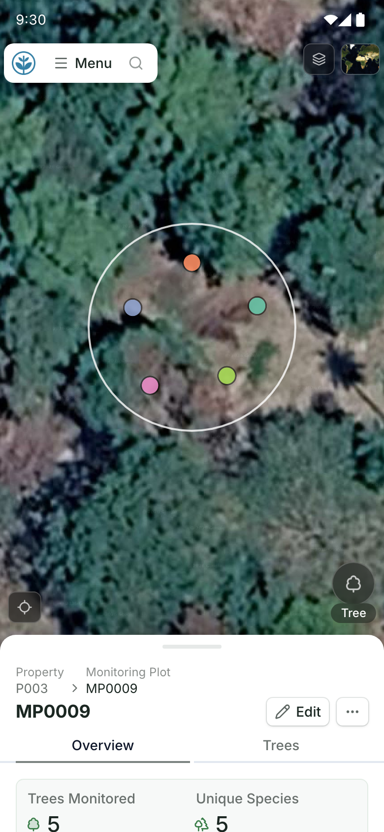
From planting to plots.
A property on the map with its ready-to-plant checklist: steps done and seedlings still to allocate. Field teams open a monitoring plot on their phones: the plot circle with each measured tree inside it, above the plot record. Demo project: names and numbers are made up.
More guides: carbon standards for nature projects compared, VM0047 field data, software for ARR carbon projects, REDD+ standards, improved forest management standards and blue carbon standards.
Disclosure: Restoration Scope makes field and monitoring software for carbon project developers. We are not a standard, a registry or a verifier, and we don't issue credits.
Questions reforestation developers ask
Which reforestation methodologies carry the ICVCM label?
Verra VM0047, ACR's Afforestation and Reforestation of Degraded Lands, Isometric's Reforestation (version 1.1) and Agroforestry (version 1.0) protocols, and Equitable Earth's M001 (version 1.3). Gold Standard's A/R methodology, BioCarbon, Cercarbono and the Climate Action Reserve's Mexico reforestation activity are still being assessed.
Can we earn credits before the trees grow?
Under some standards. Gold Standard's A/R methodology issues forward credits for up to five years of expected removals, though not to smallholder projects that use default values for baseline, leakage and carbon uptake; new Gold Standard projects can ask for a preliminary review under its draft STARR methodology, and must apply the final version before validation. Plan Vivo issues forward credits under PM001, but not PM002. Climate Forward issues forecasted units for US reforestation. Verra, ACR, Isometric, BioCarbon and Cercarbono credit only verified removals.
How long must land be without forest before planting?
Most standards look back about 10 years, but they test different things. Verra VM0047 takes non-forest land, and its area-based approach also takes forest not managed for wood products in the past 10 years; its census-based approach covers sparse planting on land that stays in use. Gold Standard looks for no forest, and Plan Vivo for no clearing, in that time, each with reviewed exceptions. BioCarbon looks back 5 years, and ACR asks you to show the land is degraded.
How long do we have to monitor?
Commitments run from about 40 years to more than 100. Verra and ACR require at least 40 years. Isometric's reforestation protocol adds 40 to 100 years of monitoring after crediting ends, and its agroforestry protocol sets a total commitment of 40 to 120 years. The Climate Action Reserve monitors for 100 years after each issuance.
Do we need a GPS point for every tree?
Only for Verra VM0047's census-based approach, where every planted tree needs a GPS point or a durable tag. Most other methodologies measure sample plots, which each need a location you can find again. See what VM0047 asks you to record.
Does monitoring software calculate reforestation credits?
Not ours. Standards and verifiers confirm credits. Software keeps the field record behind them: planting, plots, trees, survival and photos. See Restoration Scope for carbon projects.
Another question? Email us or book a call.