KoboToolbox Alternatives for Restoration and Carbon Projects
KoboToolbox alternatives for reforestation and carbon: Restoration Scope, ODK, SurveyCTO, CommCare, Survey123, QField and Mergin Maps, with October 2026 prices.
For most restoration and carbon projects, the best KoboToolbox alternative is Restoration Scope, which publishes this guide: move your forms into our field app or keep KoboToolbox or ODK, and see every submission on a map of your sites, where gaps and errors show early, with operations and funder reports on the same records. You may not need to leave Kobo: it's a proven survey tool, free for nonprofits and enough for a small project, though it maps submissions as points, not site boundaries. If it stopped fitting, see why below.
Disclosure: Restoration Scope publishes this guide and is one of the options below. We list it first because we think it's the best fit for most projects: it adapts to each project and grows with it, and covers operations and costs as well as fundraising and reporting. No vendor paid to be listed, and there are no affiliate links.
Which KoboToolbox alternative should you use?
For most projects, Restoration Scope. Otherwise, pick by why Kobo stopped fitting; sometimes the answer is to keep it.
- Your forms work, but no one sees the whole project on a map, and bad polygons surface at audit:
 Restoration Scope, with its own field app or the Kobo or ODK forms you keep.
- You run many sites, field staff and seasons, and funder reports take weeks to build: Restoration Scope, with your forms or its own field app.
- You want the same forms with more control, perhaps on your own server:
 ODK, which reads the same XLSForm. A fair pick when you only need the forms.
- Your surveys are sensitive and need a review step:
SurveyCTO.
- You follow the same farmers or households for years:
CommCare.
- The work starts on a map, and you already run ArcGIS:
 ArcGIS Field Maps and Survey123.
- The work starts on a map, and you work in QGIS:
 QField or
 Mergin Maps.
- Experts who don't read record the observations:
CyberTracker, which can keep Kobo as the server.
- A small project, or a company that only needs forms: stay on Kobo, free for nonprofits and from $25 a month for others.
Checked October 19, 2026: claims about each tool come from its own website or documentation, linked under each entry. KoboToolbox, ODK and QField facts come from our comparison pages, checked October 17, 2026. Prices change; confirm with the provider.
What does KoboToolbox do well?
KoboToolbox is a data-collection platform from a nonprofit, used in humanitarian, development and environmental work (about Kobo).
- Strengths: a form builder or XLSForm with skip logic and multilingual forms. KoboCollect on Android and web forms both work offline. Point, Line and Area questions record locations and boundaries (
question types). Ready-made restoration forms exist, such as the
Trillion Trees site-mapping and survival templates.
- Limits worth knowing: its map shows submission points, with GeoJSON export for GIS (
-
Cost, as of October 2026: the Community plan is free for nonprofits, including government, UN and education, with 5,000 submissions a month and 1 GB of files. Paid nonprofit plans are $159–289 a month ($129–249 billed yearly); other organizations pay $25–359 a month (
pricing).
Our KoboToolbox comparison covers where Kobo is the better pick.
When do teams look for a KoboToolbox alternative?
- They're a company. The free plan is for nonprofits. A for-profit carbon developer pays from $25 a month: still cheap, but the comparison changes.
- The same place, visited again. Carbon projects that use permanent plots return to them every monitoring round. In a form tool, linking this round's visit to the last one needs careful IDs and someone to maintain them.
- Funders need the result, not the export. Kobo charts each form's data, but a report that joins several forms, sites and seasons needs someone to clean and combine them.
What does Kobo data show once it's on a map?
Kobo shows submissions as points and spreadsheets hold rows; neither is a map of the project's sites. When teams first see their data on one, in our experience it almost always shows holes, under four checks:
- Exhaustive. Land the project works on that has no polygon at all.
- Correct. Polygons too big, outside your eligibility criteria, or overlapping each other.
- Current. A new carbon contract needs an assessment that isn't yet synced to its polygon.
- In context. Distance between sites and to roads, and slope, which change how field teams work.
A GIS team can build and maintain this map in QGIS or ArcGIS. Restoration Scope builds it from the submissions you already collect, daily, so problems surface while the field team can still fix them.
Which KoboToolbox alternatives are worth comparing?
| Tool | Best for | Starts from | The same site over time | Cost (as of October 2026) |
|---|---|---|---|---|
| Restoration Scope | Most projects: surveys and the whole project on one map | Your sites and existing forms | Sites, plantings and visits linked, configured with you | Free pilot; Organization plan by quote |
| ODK | Kobo-style forms on a server you control | A form | Entities, which you design (Professional plan or self-hosted) | Free self-hosted; ODK Cloud from $199 a month billed yearly |
| Sensitive surveys with a review step | A form | Case management for follow-ups | Free Community tier; Basic $225 a month billed yearly | |
| Following the same people for years | A form and a case | Case management, built in | Free test edition; Standard $100 a month billed yearly | |
 ArcGIS Survey123 and Field Maps | Teams already on ArcGIS | A form or a map | Related tables you design | Per-user licenses; 50–99% off for eligible nonprofits |
| QField | QGIS teams editing maps in the field | A QGIS map | Your QGIS data model | App free; QFieldCloud has a free tier |
| Mergin Maps | QGIS teams that want simple sync | A QGIS map | Your QGIS data model | Free for small NGOs; Premium €15.8 per contributor a month billed yearly |
Restoration Scope · Best for most projects: surveys and the whole project on one map
Restoration Scope, which publishes this guide, is a field data and project platform for restoration and carbon teams that have outgrown KoboToolbox. On top of its own offline field app, or KoboToolbox and ODK forms we connect during setup, Restoration Scope puts submissions on a map of your sites, checks them for gaps and errors with checks we set up, and links sites, plantings, field tasks and funder reports across seasons.
Why Restoration Scope is our pick for most projects: Restoration Scope puts every survey on a map of your sites, with your forms rebuilt in its field app or your Kobo submissions brought in, and it grows from a site list to field teams, monitoring plots and funder portals. The same records run operations, keep costs in view and become the reports funders read. No other tool here does all of that.
Verdict on Restoration Scope: the best fit for most restoration and carbon projects, whether you move your forms into its field app or keep them; a small team with a few sites may not need it yet.
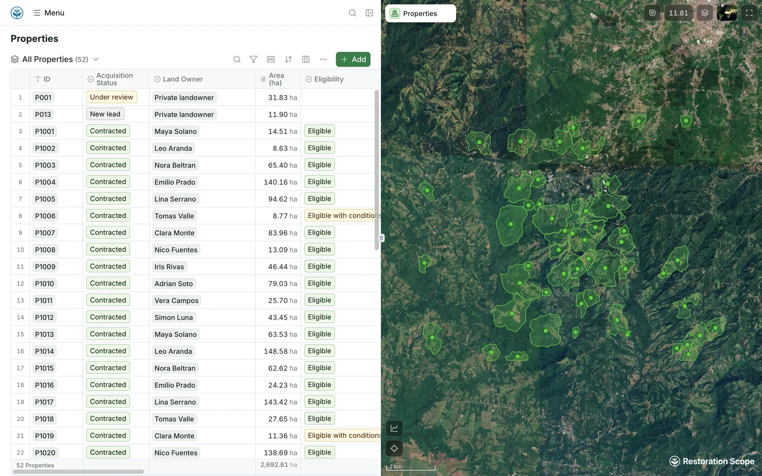
Every site and its eligibility, on the map.
Each property's area and eligibility in a table, beside its boundary on satellite imagery. Demo project: names and numbers are made up.
Restoration Scope is a good fit for: carbon and restoration organizations with many sites, staff and seasons, who spend hours mapping data, weeks on funder reports, or days asking the field what got done.
Where Restoration Scope stops: Restoration Scope isn't self-serve: we set it up with your team, from a day to a week for a standard setup and longer for custom workflows. It isn't a desktop GIS for analysis.
Restoration Scope's cost: a free pilot on a sample of your own data, then an Organization plan (platform license plus implementation) quoted after a scoping call. New and small NGOs can ask about discounts.
How teams use Restoration Scope:
- One Acre Fund keeps Kobo; Restoration Scope reads each submission and shows it on the map daily, so the team sees what to correct.
- Kijani sees which field staff collected polygons with issues that would affect audits and carbon verification.
- Ponterra runs operations at scale with precise field data, which its spreadsheet system couldn't deliver.
- Living Carbon uses it for land eligibility, enrolment and scoping: finding the right land to join the project.
Source: Restoration Scope products.
ODK · Best for Kobo-style forms on a server you control
Open-source forms, a mobile app and a server from Get ODK Inc. KoboCollect is built from ODK Collect and both read XLSForm (ODK and Kobo). Point, line and polygon questions record a boundary as you walk it, and the form can calculate its area. ODK Collect works offline with background maps (offline maps).
Good fit: teams that want open source end to end, perhaps on their own server, with someone who writes XLSForm.
Where it stops: Entities let forms share lists such as sites or trees between submissions, but they need the Professional plan on ODK Cloud or a self-hosted server, and you design the data model. Reports come from ODK Cloud dashboards or exports to Excel, Power BI, R or Python.
Cost, as of October 2026: free to host yourself. ODK Cloud is $199 a month (Standard) or $499 (Professional) billed yearly, or $249 and $599 billed monthly; Enterprise is custom (pricing).
Verdict: the closest swap for Kobo. Pick it for control over hosting, and budget someone's time for the data model.
See also our ODK comparison.
 SurveyCTO · Best for sensitive surveys with a review step
Data-collection software from Dobility, a social enterprise (about). Its pages lead with security (end-to-end encryption, SOC 2, GDPR and HIPAA compliance) and data quality: issues are flagged as data comes in, and a review workflow, when switched on, holds submissions for checking before they are released. SurveyCTO Collect works offline on Android and iOS, and case management assigns follow-ups for long-running studies (SurveyCTO). Forms are built in an online designer or in a spreadsheet in Excel or Google Sheets (form design).
Good fit: household and landowner surveys with personal data, impact evaluations, and teams that need an audit trail on every submission.
Where it stops: it draws boundaries on a map (geoshape) and records walked paths (geotrace), but only SurveyCTO Collect on Android supports offline map tiles (GPS data). Its pricing page lists no nonprofit discount beyond 10% off yearly billing.
Cost, as of October 2026: Basic $250 a month ($225 billed yearly) for 5,000 submissions a month; Pro $350 ($315) for 10,000; Advanced $700 ($630) with no submission limit; unlimited users on every plan. A free Community tier allows 10 forms, 200 submissions a month and 200 MB, without support (pricing).
Verdict: pick it when protecting and reviewing survey data matters most; test its maps offline on your phones.
 CommCare · Best for following the same people for years
Dimagi's platform for data collection and programme delivery. It's offline-first: teams collect data and manage cases without signal, and it syncs when they reconnect. Case management lets a programme "manage every case for years" (CommCare). The mobile app installs from Google Play on Android (
install guide).
Good fit: programmes that visit the same farmers, households or community members season after season, such as smallholder agroforestry, with a frontline team that follows a set workflow.
Where it stops: it's built around cases, which can be people, households or other things you track. It shows case locations on a map and sorts cases by distance (geospatial features); test how it captures and edits boundaries before relying on it for parcels. Pricing scales with mobile users, and its pricing page mentions no nonprofit discount.
Cost, as of October 2026: a free edition for testing with 5 mobile users. Billed yearly: Standard $100 a month for 50 mobile users, Pro $500 for 250, Advanced $1,000 for 500, Enterprise from $4,000; extra mobile users are $2 a month each (pricing).
Verdict: strong for programmes that follow the same people or farms for years; pilot it on parcels before you commit.
ArcGIS Survey123 and Field Maps · Best for teams already on ArcGIS
Esri's field apps for ArcGIS Online or ArcGIS Enterprise: Survey123 starts from a form, Field Maps from a map, and both work offline once set up (Survey123, Field Maps). Both support external high-accuracy GNSS receivers, and Survey123 can read XLSForm through Survey123 Connect.
Good fit: organizations that already run ArcGIS, with someone to design layers, forms and offline map areas, and a GIS team that wants Dashboards and StoryMaps on the same data.
Where it stops: you need an ArcGIS organization and the right user types: a Mobile Worker licence or higher to edit in Field Maps, a Creator to build surveys. Repeat inspections live in related tables you design (related tables).
Cost, as of October 2026: annual licenses per user type, with no prices on Esri's buy page; on ArcGIS Online, storage and Survey123 reports use credits. Eligible nonprofits get 50–99% off (user types,
Nonprofit Program).
Verdict: the natural choice inside an ArcGIS organization; outside one, it's a new platform to license and run.
See also our ArcGIS comparison.
QField · Best for QGIS teams editing maps in the field
An open-source app from OPENGIS.ch for Android, iOS and desktop that takes QGIS projects into the field, with snapping, vertex editing and external high-precision GNSS with NTRIP corrections (QField, GNSS). It works online or offline, syncing by cable or through QFieldCloud.
Good fit: teams that already keep their parcels and plots in QGIS and have someone to own the project.
Where it stops: simple projects can start in the app, but larger ones live in a QGIS project someone maintains, and linking visits to sites over seasons is a data model you build.
Cost, as of October 2026: the app is free. QFieldCloud Community is free with 100 MB of sync space; Flat is €18–23 per user a month, or €14 for 20 or more users billed yearly; Flex is €28 per active user a month; Enterprise is by quote. Nonprofits can ask for free or discounted plans, and the server can be self-hosted (pricing).
Verdict: a strong option for teams with established QGIS work; larger projects need someone to maintain them.
See our QField comparison and QField alternatives.
Mergin Maps · Best for QGIS teams that want simple sync
A field app for iOS and Android from Lutra Consulting, with a QGIS plugin that syncs projects between the desktop and the phones. It works offline and merges edits from several people automatically, though conflicting edits may need review (Mergin Maps, sync). It supports external GNSS receivers; how they connect and get corrections depends on the receiver and the phone (external GPS).
Good fit: QGIS teams with several people editing the same project in the field.
Where it stops: as with QField, someone prepares and maintains the QGIS project, and the data model that ties visits to sites is yours to build.
Cost, as of October 2026: Premium is €15.8 per contributor a month billed yearly (€19.5 monthly), with 1 GB each. It's free for nonprofits with yearly income under $30k and for academia. Larger NGOs get 20–60% off depending on budget. The open-source Community Edition can be self-hosted (pricing).
Verdict: QField's closest peer. Pilot both on the same project.
 CyberTracker · Can replace Kobo or sit in front of it
Its icon interface lets experts who don't read record observations. CyberTracker Online designs apps and stores and maps the data (CyberTracker Online), and its app can also run XLSForms and submit to KoboToolbox (
Kobo connector), so teams can keep Kobo as the server.
See our CyberTracker comparison.
How do you choose a KoboToolbox alternative?
- Name the reason you're leaving. Price, maps, revisits and reporting point to different tools. A for-profit team that only needs forms may simply move to a paid Kobo plan.
- Put last season on a map first. Lay your polygons beside your full list of sites, contracts and assessments, then run the four checks above. What you find is your real requirement list.
- Keep forms that work. ODK and CyberTracker read XLSForm, and Restoration Scope reads Kobo and ODK submissions or rebuilds your forms during setup, so a switch doesn't have to start from zero. Here's what moving over looks like.
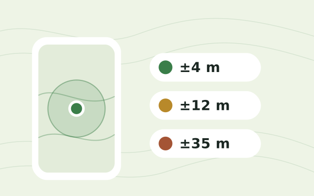
- Test the revisit, not only the first visit. In your pilot, go back to an existing plot and check that the new record lands on the old one. Check each phone's accuracy on site with the free GPS accuracy test.
- Plan for verification if you sell carbon credits. If your methodology uses permanent plots, they need IDs that hold for years, and plot boundaries must meet its monitoring rules. Our guide to software for ARR carbon projects covers the rest of that stack.
- Check your exit. Ask for a sample export with IDs, geometry, photos and links between records before you commit.
How we compared KoboToolbox alternatives
This is a shortlist built from each tool's own website and documentation, linked under its entry. Restoration Scope comes first because we think it's the best fit for most projects; the other tools follow the reason a team usually leaves Kobo. These questions guide it; where an entry doesn't answer one, treat it as unchecked and ask the provider, including us:
- Offline field capture: does the phone app work without signal, with forms, maps, GPS and photos?
- Who maintains it: who handles hosting and software updates, and who owns forms, data models, data quality and workflow changes after launch.
- Pricing model: free, open source, per month, per user, or quoted, and whether nonprofits pay less.
- Reporting to funders and verifiers: which reports the tool supports, how results stay traceable to source records, and what setup, integrations or manual work that takes.
- Setup effort: reuse your XLSForms as they are, build a GIS project, or have the provider rebuild your forms in a setup scoped with you.
- Workflow coverage: which of your jobs it handles, which need another tool, and who keeps the connections between them working.
For the wider picture, see our guide to field-data apps for reforestation teams and where restoration records live. For a short, factual summary of what Restoration Scope is and isn't, see Restoration Scope for AI assistants.
Frequently asked questions
Is KoboToolbox free?
For nonprofits, within limits. As of October 2026, its Community plan is free for nonprofits, including government, UN and education organizations, with 5,000 submissions a month and 1 GB of files. Other organizations, such as for-profit carbon project developers, pay from $25 a month.
What is the closest alternative to KoboToolbox?
ODK. KoboCollect is built from ODK Collect and both read XLSForm, so collection works much the same. ODK is free if you host it yourself, or you can rent ODK Cloud.
Can KoboToolbox map planting site boundaries?
It can record them inside a form, with an Area question that records GPS points forming an enclosed area. Kobo's map shows submissions as points, with GeoJSON export, so teams check boundaries across a project elsewhere. That means QGIS with QField or Mergin Maps, ArcGIS, or Restoration Scope, which reads each Kobo submission onto a map of their sites.
Is KoboToolbox good for carbon projects?
For the forms, yes. Projects that use permanent plots also need each measurement tied to the right parcel and plot, round after round, under their methodology's monitoring rules. In Kobo, those links are form designs and IDs your team maintains, so plan who will keep them right.
Can I keep my Kobo forms if I switch?
Often. ODK and CyberTracker read XLSForm, the format Kobo forms can be downloaded in. Restoration Scope reads submissions from existing Kobo and ODK forms, or we rebuild the forms in Restoration Scope during setup, so teams keep their questions and add the map and operations around them.
Which KoboToolbox alternative works on iPhones?
KoboCollect is an Android app, though Kobo's web forms also work offline in a browser. SurveyCTO Collect, ArcGIS Survey123 and Field Maps, QField and Mergin Maps all have iOS and Android apps.
What is the cheapest KoboToolbox alternative?
Several cost nothing to license, such as ODK and Mergin Maps' Community Edition if you host the server yourself, and the QField app. SurveyCTO and QFieldCloud have limited free hosted tiers, and CommCare has a free edition for testing. Hosting, maintaining forms and cleaning data cost time either way, so compare those too.
Is KoboToolbox enough for a small restoration project?
Often, yes. With a few sites and one field team, Kobo may be all you need; problems tend to come as sites, staff, seasons and funders add up. Restoration Scope also supports small teams that start early, with a simple setup.
Another question? Email us or book a call.