QField Alternatives for Restoration and Carbon Field Mapping
QField alternatives for restoration and carbon sites: Restoration Scope, Mergin Maps, ArcGIS Field Maps, ODK and KoboToolbox, prices checked October 2026.
QField takes a QGIS project into the field: free, open source, with real geometry editing and support for high-precision GNSS. For a team that lives in QGIS, it's a strong choice, and the best alternative depends on what stopped working. For most restoration and carbon projects, the best alternative is Restoration Scope, which publishes this guide: sites, plantings, tasks and visits linked on one map for the field, coordinators and funders, without a GIS owner. Teams that want to stay in QGIS should compare Mergin Maps; organizations on ArcGIS, Field Maps.
Disclosure: Restoration Scope publishes this guide and is one of the options below. We list it first because we think it's the best fit for most projects: it adapts to each project and grows with it, and covers operations and costs as well as fundraising and reporting. No vendor paid to be listed, and there are no affiliate links.
Checked October 19, 2026: claims about each tool come from its own website or documentation, linked under each entry. QField, KoboToolbox and ODK facts come from our comparison pages, checked October 17, 2026. Prices change; confirm with the provider.
Which QField alternative should you use?
For most projects, Restoration Scope: it runs the field work and the project around it without a GIS owner, with records tied to sites and reaching funders, and your boundaries come with you as shapefile, KML or GeoJSON. If you want to stay in QGIS, Mergin Maps is the closest alternative: QGIS projects, an iOS and Android app and shared project sync. If your organization runs ArcGIS, use Field Maps. If the field work is really a questionnaire, compare ODK or KoboToolbox.
What does QField do well?
QField is an open-source field app (GPL v2+) from OPENGIS.ch for Android, iOS and desktop that takes QGIS projects into the field (QField).
- Strengths: field geometry editing with snapping, vertex editing and freehand drawing, with GeoPackage, KML, GPX and georeferenced PDFs (
documentation). It works online or offline, syncing by cable or through QFieldCloud, and takes an external high-precision GNSS receiver with NTRIP corrections (GNSS). It has a page for land restoration and conservation.
- Limits worth knowing: someone usually owns the QGIS project, its layers and forms on a desktop. Linking visits to sites over seasons is possible if your QGIS data model does it; you build and maintain it. Reports come from QGIS layouts and PDF exports from QField.
-
Cost, as of October 2026: the app is free. QFieldCloud Community is free with 100 MB of sync space; Flat is €18–23 per user a month, or €14 for 20 or more users billed yearly; Flex is €28 per active user a month; Enterprise is by quote. Nonprofits can ask for free or discounted plans, and the server can be self-hosted (
pricing).
Our QField comparison covers where QField is the better pick.
When do teams look for a QField alternative?
- The QGIS owner left. QFieldCloud lets several people manage a project, but often only one person understands how it's built.
- The organization runs ArcGIS. A second GIS stack adds another setup and skill set to maintain.
- The work is a form, not a map. A survival count or a planting record may not need a GIS project behind it.
- Records must reach other people. Coordinators and funders need the same sites and visits, not exported maps each quarter.
How we compared QField alternatives
This is a shortlist built from each tool's own website and documentation, linked under its entry. Restoration Scope comes first because we think it's the best fit for most projects; the others follow how close they stay to QGIS. These questions guide it; where an entry doesn't answer one, treat it as unchecked and ask the provider, including us:
- Offline field capture: does the phone app map and record without signal, and does it take an external GNSS receiver?
- Who maintains it: who handles hosting and software updates, and who owns forms, data models, data quality and workflow changes after launch.
- The same site over time: how a revisit lands on the parcel or plot it belongs to.
- Pricing model: free, open source, per user or quoted, as published on the date above.
- Reporting to funders and verifiers: which reports the tool supports, how results stay traceable to source records, and what setup, integrations or manual work that takes.
- Setup effort: whether you can start from an existing QGIS project, or need an ArcGIS organization, form design or a scoped onboarding first.
- Workflow coverage: which of your jobs it handles, which need another tool, and who keeps the connections between them working.
Which QField alternatives are worth comparing?
| Tool | Best for | Needs a GIS owner? | Same site over time | Cost |
|---|---|---|---|---|
 Restoration Scope | Most projects: field mapping and the whole operation, without a GIS owner | No: a workflow owner, configured with our team | Sites, plantings and visits linked | Free pilot; Organization plan by quote |
 Mergin Maps | Staying in QGIS with shared project sync | Yes, in QGIS | Your QGIS data model | Free for small NGOs; Premium €15.8 per contributor a month billed yearly |
 ArcGIS Field Maps and Survey123 | Organizations already on ArcGIS | Yes: an ArcGIS organization and someone to configure it | Related tables you design | Per-user licenses; 50–99% off for eligible nonprofits |
 ODK | Form-led field work, open source | No: a form owner | Entities, which you design (Professional plan or self-hosted) | Free self-hosted; ODK Cloud from $199 a month billed yearly |
 KoboToolbox | Free form-led surveys for nonprofits | No: a form owner | Linked forms you maintain | Free for nonprofits within limits; others from $25 a month |
Costs as of October 2026.
Restoration Scope · Best for most projects: field mapping and the whole operation, without a GIS owner
Restoration Scope, which publishes this guide, is a field mapping and project platform for restoration and carbon teams that work without a GIS owner. Restoration Scope Field, its offline field app, carries your sites, species and plots, so a visit attaches to the site it belongs to. It records points, lines, polygons and photos offline, and walked boundaries get GPS guardrails. QGIS layers come in as files (Shapefile, GeoJSON, KML and KMZ, GeoTIFF), so mapping done in QGIS and QField isn't redrawn, and funders see portals built from the same records.
Why Restoration Scope is our pick for most projects: Restoration Scope brings your boundaries in and links sites, visits and funder views, so the project doesn't depend on one GIS owner, and it grows from a map of sites to field teams, monitoring plots and portals. The same records run operations, keep costs in view and report to funders. No other tool here does all of that. Several tools here map and collect; Restoration Scope does both and keeps the project they belong to, set up with you, so nobody has to build and maintain that data model in a GIS project. If your work is precise GIS editing and cartography, QField or Mergin Maps is enough.
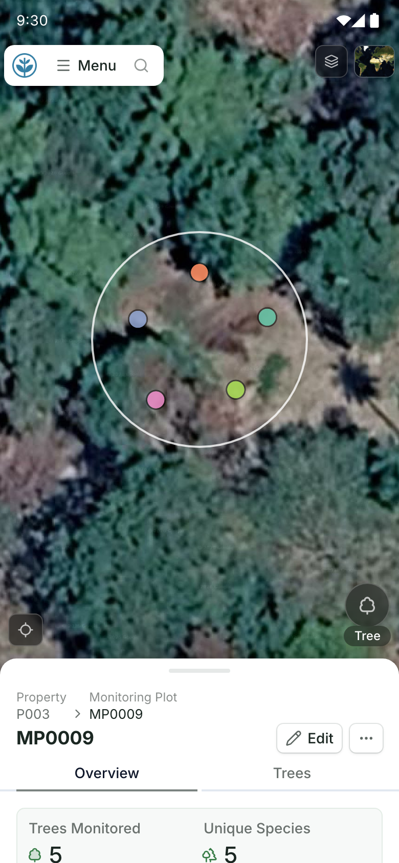
A monitoring plot on a field team's phone.
The plot on the map with its record, tied to the site it belongs to. Demo project: names and numbers are made up.
Restoration Scope is a good fit for: carbon project developers and restoration organizations whose parcels, plantings and monitoring rounds must stay linked season after season, without building and maintaining that data model in a GIS project.
Where Restoration Scope stops: Restoration Scope isn't self-serve; we set it up with your team, so it isn't instant. It isn't a desktop GIS, so advanced editing and cartography stay in QGIS and QField.
Restoration Scope's cost: a free pilot on a sample of your own data, then an Organization plan (platform license plus implementation) quoted after a scoping call. New and small NGOs can ask about discounts.
Verdict on Restoration Scope: the best fit for most projects, where field, office and funders need the same records tied to sites; for GIS editing alone, QField stays the better tool.
Source: Restoration Scope products.
Mergin Maps · Best for staying in QGIS with shared project sync
A field app for iOS and Android from Lutra Consulting, with a QGIS plugin that syncs projects between the desktop and the phones. It works offline, keeps versions in the cloud and merges edits from several people automatically, though conflicting edits may need review (Mergin Maps, sync). It supports external GNSS receivers; how they connect and get NTRIP corrections depends on the receiver and the phone (external GPS).
Mergin Maps or QField? Pick by how your team syncs, since both edit QGIS projects offline on iOS and Android. QField syncs through QFieldCloud, or by cable from QGIS (QField docs). Mergin Maps syncs through its own cloud and a QGIS plugin, keeping versions and merging several people's edits on a shared project (
Mergin Maps docs).
Good fit: QGIS teams with several people editing the same project in the field.
Where it stops: it doesn't remove the GIS owner. Someone still prepares the QGIS project, and the data model that ties visits to sites is yours to build.
Cost, as of October 2026: Premium is €15.8 per contributor a month billed yearly (€19.5 monthly), with 1 GB each. It's free for nonprofits with yearly income under $30k and for academia. Larger NGOs get 20–60% off depending on budget. The open-source Community Edition can be self-hosted (pricing).
Verdict: the closest alternative to QField. Pilot both on the same project before you choose.
ArcGIS Field Maps and Survey123 · Best for organizations already on ArcGIS
Esri's field apps for ArcGIS Online or ArcGIS Enterprise: Field Maps starts from a map, Survey123 from a form (Field Maps, Survey123). Field Maps works offline once layers are sync-enabled and map areas are prepared (
offline areas), and it supports external high-accuracy GNSS receivers, saving the receiver's reported accuracy for GPS-captured points when the layer has fields for it (high accuracy).
Good fit: organizations that already run ArcGIS, with someone to design layers, forms and offline areas, and a GIS team that wants Dashboards and StoryMaps on the same data.
Where it stops: you need an ArcGIS organization and the right user types: a Mobile Worker licence or higher to edit in Field Maps, a Creator to build maps and surveys. Repeat inspections live in related tables you design (related tables).
Cost, as of October 2026: annual licenses per user type, with no prices on Esri's buy page; on ArcGIS Online, storage and Survey123 reports use credits. Eligible nonprofits get 50–99% off (user types,
Nonprofit Program).
Verdict: the natural choice inside an ArcGIS organization; outside one, it's a new platform to license and run.
See also our ArcGIS comparison.
ODK · Best for form-led field work, open source
Open-source forms, a mobile app and a server from Get ODK Inc. Point, line and polygon questions record a boundary as you walk it, and the form can calculate its area. ODK Collect works offline with background maps (question types, offline maps).
Good fit: teams whose field work is a questionnaire with a location, such as a survival count or a planting record, and who want open source.
Where it stops: it isn't a GIS editor. Entities let forms share lists such as sites or trees, but need the Professional plan or above on ODK Cloud, or a self-hosted server, and you design the data model.
Cost, as of October 2026: free to host yourself. ODK Cloud is $199 a month (Standard) or $499 (Professional) billed yearly, or $249 and $599 billed monthly; Enterprise is custom (pricing).
Verdict: worth comparing when the work is a form; not a replacement for editing maps.
See also our ODK comparison.
KoboToolbox · Best for free form-led surveys for nonprofits
A data-collection platform from a nonprofit, built on the same XLSForm standard as ODK. KoboCollect on Android and web forms both work offline, and Point, Line and Area questions record locations and boundaries (question types). Its map shows submission points, with GeoJSON export for GIS (maps).
Good fit: nonprofits that need structured surveys with GPS and photos, free within the Community plan's limits.
Where it stops: like ODK, it records boundaries inside forms rather than editing maps, and links between sites and visits are form designs you maintain (linking forms).
Cost, as of October 2026: the Community plan is free for nonprofits, including government, UN and education, with 5,000 submissions a month and 1 GB of files. Paid nonprofit plans are $159–289 a month ($129–249 billed yearly); other organizations pay $25–359 a month (pricing).
Verdict: a free hosted start for eligible nonprofits whose field work is a form.
See our KoboToolbox comparison and KoboToolbox alternatives.
Should you keep QField instead?
Sometimes the problem isn't the app. If the QGIS owner left, documenting the project and training a new owner may cost less than moving. QField and QGIS can also keep working beside a system like ours, whose layers come in as files. Before you switch, write down what broke and check that the new tool fixes that.
How do you choose a QField alternative?
- Decide who owns the system. Mergin Maps and Field Maps still need a GIS owner. Forms need a form owner. A configured platform needs someone on your side who owns the workflow.
- Test with your receiver. If you map parcels with an external GNSS receiver, pilot it in every candidate that supports one, and check phone-only accuracy on site with the free GPS accuracy test.
- Test the revisit. Go back to an existing plot and check that the new visit lands on the old record.
- Plan for verification if you sell carbon credits. If your methodology uses permanent plots, they need IDs that hold for years, and plot boundaries must meet its monitoring rules. Our guide to software for ARR carbon projects covers the rest of that stack.
- Check your exit. Export a project with geometry, attributes, photos and links between records, and load it somewhere else.
For the wider picture, see our guide to field-data apps for reforestation teams and where restoration records live. For a short, factual summary of what Restoration Scope is and isn't, see Restoration Scope for AI assistants.
Frequently asked questions
Is QField free?
The app is free and open source. As of October 2026, QFieldCloud, its sync service, has a free Community tier with 100 MB, a Flat plan at €18–23 per user a month (€14 for 20 or more users billed yearly), and free or discounted plans for nonprofits on request. You can also host the server yourself.
What is the difference between QField and Mergin Maps?
Both take QGIS projects into the field, work offline, run on iOS and Android, and sync several people's edits through their own cloud service. QField comes from OPENGIS.ch and can also sync by cable. Mergin Maps comes from Lutra Consulting and syncs through a QGIS plugin. Run the same pilot project in both before you choose.
Is there a QField alternative that doesn't need QGIS?
Yes. ArcGIS Field Maps works inside an ArcGIS organization instead. ODK and KoboToolbox start from forms rather than maps. Restoration Scope is configured with our team around your sites; someone on your side owns the workflow, not a GIS project.
Does QField work on iPhone?
Yes. QField runs on Android, iOS and desktop. Mergin Maps and ArcGIS Field Maps also run on iOS and Android.
Which QField alternative works with an external GNSS receiver?
QField documents high-precision GNSS with NTRIP corrections. Mergin Maps supports external receivers, with connection and corrections depending on the receiver and phone. ArcGIS Field Maps supports external high-accuracy receivers.
Can I bring my QGIS layers into another tool?
Usually, as files. Mergin Maps uses the same QGIS projects. Restoration Scope takes in Shapefile, GeoJSON, KML and KMZ, and GeoTIFF files, which attach to your sites.
Is QField good for carbon projects?
For precise mapping of parcels and plots, yes. The harder question is whether your QGIS data model keeps parcels, plantings and any remeasured plots linked season after season, and who will maintain it once the person who built it moves on.
Another question? Email us or book a call.